FORWARD
This master planning effort began in 1989 when the Ukrainian government acted on its commitment to preserve the national cultural heritage by commissioning the Scientific Research Institute of Architecture and City Planning of Kyiv, Kyiv-VNITAG. Its goal was to develop a historical-architectural base plan and preservation plan for the historical center of Sevastopol. In 1991, a follow-up project addressed the protection of historical and cultural monuments, and set initial boundaries for the National Preserve of Tauric Chersonesos, consisting of the Ancient City, the Museum in the Ancient City, and the ancient Chora (territory) on the Heraclean Peninsula at Sevastopol. The following year Professor Joseph Coleman Carter, Director of the Institute of Classical Archaeology (ICA) at the University of Texas, and other foreign specialists recruited to assist the research arrived, setting in motion a multi-year collaboration that precipitated the involvement of this design team. [Visit websites: www.utexas.research/ICAand www.Chersonesos.org].
The collaborative planning of the 1998 campaign prescribed a sequence of events designed to establish a mechanism for executing a physical design. Many of those plans are now complete and only in need of compilation for constructive use. Inventories, surveys, histories, determination of significance, condition assessments, description of user needs, and interpretive plan all essentially had been completed by the Preserve administrators and government agencies prior to 1998. Those items have now been assembled through literature search and interviews in the current campaign. This master plan is based on that foundation and is a continuation of the prior campaign's work.
The archaeological Preserve, once termed the Pompeii of Crimea, will develop in the midst of a vigorous metropolitan fabric. This fabric will experience explosive transformation as Ukraine's new economy, new government, and new patterns of land ownership take hold. The master plan integrates the Preserve in the fabric of the surrounding contemporary city. The proposed Preserve would control land fundamental to the structure of modern Sevastopol. Severing the current generous public access to the area, even if only an unintended consequence preservation, would undermine the public support needed in Sevastopol's current economic and social context. The archaeological Preserve must make sense to a general populace that is under tremendous sociological strain after the political and economic transformation at the end of the Twentieth Century. The citizens of Sevastopol must be constructively engaged and encouraged to actively support the master plan in order to make the notion of an archaeological Preserve viable and sustainable. Otherwise, the citizens would find it difficult to rationalize the dedication of so much of their resources of land, time, and money to the Preserve's endeavors.
The importance and the potential of the National Preserve of Tauric Chersonesos have been widely recognized by the international agencies and foundations as well as by the Ukrainian government. Properly realized plans for enhancement of the
Preserve will not only protect a major cultural treasure of world importance, but also contribute significantly to the region's economy by attracting international tourism and the infrastructure investment that a cultural magnet of its importance would have.
The problems have been sufficiently defined; this master plan proposes solutions. The plan consists of three phases of construction and renovation providing for the Preserve's needs over the next twenty years. The first concentrates on property currently under the Preserve's nearly unilateral control and occupies the first six years of effort. The second phase encompasses Preserve property that requires cooperation from the maritime governmental agencies and others to develop, and is assumed to take place during years seven through ten. The final phase involves land that will eventually be ceded to the Preserve by the military authorities, and occupies the final ten years of development. That sequence allows six years to consummate the necessary regulatory and legal agreements for Phase Two, and ten years for Phase Three.
The immediate needs of the Preserve will be addressed in Phase I of the proposed plan. Adequate artifact storage, infrastructure improvements, and additional space for scientific work in the inner-campus region are the initial focus of the plan. The existing storage facilities 'fondi' will be structurally stabilized and enlarged. Those improvements will not result in an increase of building footprints, avoiding the destruction of the undisturbed cultural layers in the soil under the inner campus. The enlargements will be accomplished through creation of attic mezzanines and, where allowed, the addition of upper floors. The latter stages of Phase I will address renovation, expansion of Preserve facilities, and vendor accommodations at the periphery of the existing campus. Those outer campus improvements will include adaptive re-use of the WWI artillery battery as a war memorial and subterranean archaeological warehouse. The existing summer student housing will be enlarged, upgraded, and reconfigured to stand away from the war monument so that the embankment's mammoth size will be revealed. The renovation of the extensive subterranean barracks and munitions spaces will provide environmentally secure storage for archaeological finds into the middle of this century. The re-use of subsurface spaces will not interfere with the integrity of the memorial structures on the surface, which will be restored and managed for display.
Improvements to the outer campus along the western and northern shores will defend against erosive wave action and accommodate the activities of swimmers in a linear shoreline promenade confined by those very same erosion protection structures. The design seeks to elicit benign behavior from the swimmers by providing the means to enjoy the shore while being segregated from the monuments. The swimmers will be provided with public restrooms and trash receptacles maintained by the Preserve and city. Those amenities will be attached to the anchorage of the shore protection structures embedded within the cliff faces. In addition to providing protected foundation conditions, that arrangement will protect the 4 shoreline's appearance by concealing the restrooms from view and coincidentally provide the swimmers with privacy. The shore protection structures will screen swimmers away from the primary Preserve grounds with appropriate barriers allowing Preserve access only at supervised, limited ticket booth locations.
Improvements along the southern edge of the campus will enhance the organization and compatibility of the restaurants and shops at the entrance to the Preserve. New businesses will be encouraged to join the existing businesses to form a retail plaza just outside the monastery gate and hotel. Although the plaza exists as a convenience to Preserve visitors, its placement serves the surrounding neighborhoods' recreation and commercial needs as well. The creation of the plaza has the additional benefit of generating ground lease revenue for the Preserve.
Phase II will confine its scope to the periphery of the existing campus concentrated in the vicinity of the ancient port. The renovation of Quarantine Bay Beach will be added to the shoreline promenade established in Phase I work. Again, amenities will be provided for swimmers in consideration of limits placed on their freedom of access to the primary Preserve grounds. The amenities will include vendor space to enhance the convenience of beach use and to further encourage beach goers' attentions toward the shore and away from abuse of the monuments. The strategy has the beneficial side effect of generating ground lease revenue for the Preserve. In addition, the existing naval structures and buildings will be reused to create a maritime museum commemorating the role naval personnel played in the rediscovery and excavation of the Ancient City, as well as their broader service to their country. The structures defining the swimming area will conceal de-watering bulkheads that will be used to establish the cofferdam necessary to effectively excavate the ancient port down to the elevations of ancient Chersonesos. That work will require the review and approval of various maritime agencies and the military.
Phase III will establish entirely new facilities for the Preserve's administrative staff, a visitors' center, hotel, and the physical plant for the proposed international archaeological field school. The existing residents and small businesses of the area at the southern and eastern extremities of this ceded land will not be displaced. The businesses, apartment buildings, and garages will be renovated and incorporated into the Preserve development. The master plan prescribes an absolute increase in the number of housing units and maintains the amount of commercial space in order to bolster the strength of the adjoining neighborhoods. The design will also provide housing opportunities and services for Preserve workers, visiting scholars and students. It is in this phase that the master plan will have the greatest beneficial impact on the local infrastructure, economy, and seashore district's public amenity level. Those new facilities will out of necessity upgrade the district's water, sewer, and electrical services. The increase of hotel beds so near the Black Sea shore could be used by the local tourist industry to strengthen Sevastopol's economy. Phase III buildings are organized around a public park that will add to the recre-
ational choices of the adjoining residential areas.
This document evaluates prior master plan initiatives in the context of Sevastopol's current situation. This reinterpretation finds room for increased private participation in all phases of proposed development. The purpose of those amendments is to increase the Preserve's interaction with the adjacent city fabric in hopes of supporting its continued growth in popularity and scope, while providing the maximum protection for its monuments. By making a positive impact on the surrounding neighborhoods, the public's support and favor so badly needed if the Preserve's preservation efforts are to succeed and endure will be encouraged.
Llano Design wishes to make the following acknowledgements:
We are grateful to Joseph Coleman Carter for inviting us to participate in this project. We are also very grateful to Galina Mikhailovna Nikolaenko and Leonid Vasilevich Marchenko for their hospitality and facilitation of the planning process.
Tatiana Bazhanova, Architect; Nikolai Andrushenko, Architect; Stanislav Ryzhov, Director Chersonesos Excavations; Lyudmila Grinenko, Museum Library; and Nonna Krasovskaya, Museum Archives for their design input and research assistance. Dr. Steven Gavel, art historian; Stan Pipkin, architecture student; Seth Bossung, architecture student; and Martha Kennan, architecture student, for their design and criticism. Lilja Bondareva, Nikitski Botanical Garden, Yalta; and Oleksiy Kalynychenko, Underwater Archaeology Center, Kiev, for introductions to the work of their respective institutions. We would also like to thank Paul Lehman and Carlos Cardova for their bellwether work in geomorphology and paleoecology and for the insight their data contributed to this project. Christopher Williams for his editorial assistance
We thank Svetlana Telenkova for her tireless work as translator and her assistance in Kiev and Sevastopol. Orest Yavtushenko, Vassily Kirichenko, Lyudmila M. Khudyakova, Victor Streltsov, Lyudmila Vera Kruck, and Raisa Tychinnskaya for their assistance at the National Preserve of Tauric Chersonesos.
With special thanks to our benefactors for their generous and far-sighted support:
The Packard Humanities Institute (PHI), Los Altos, California
The National Preserve of Tauric Chersonesos (NPTC), Sevastopol, Crimea
The Samuel H. Kress Foundation, New York, New York
The Trust for Mutual Understanding, New York, New York
American Express Corporation, through the World Monuments Watch, New York,
New York The Brown Foundation, Houston, Texas The James R. Dougherty Jr. Foundation, Beeville, Texas The Center for the Study of Ancient Territories, Austin, Texas 6
\Carl Holiday, Principal Llano Design
Alma Maldonado Holiday, Principal
Liano Design
March 2001
Introduction.................
Background Purpose & Goals Methodology
Analysis & Programming
Existing Context Site Analysis Buildings Analysis General Conclusion Proposed Program
Master Plan Proposal
Design Description Implementation
Appendix................
Endnotes Bibliography
Excerpts from Prior Studies
Table of Contents
LIST OF PHOTOGRAPHS & FIGURES
|
Page 1 |
Campaign 2000 Photograph of the "Italian Garden" |
|
Page 2 |
Photograph of the 'Gryphon', Symbol of Chersonesos (Medvedeva & Shereshersky 1996) |
|
Page 10 |
Photograph of Old Museum Interior, circa 1920 (Medvedeva & Shereshersky 1996) |
|
Page 12 |
Photograph of Ancient City Entrance, circa 1920 (Medvedeva & Shereshersky 1996) |
|
Page 20 |
Photograph of the "Tower of Xeno", circa 1920 (Medvedeva & Shereshersky 1996) |
|
Page 21 |
Excerpts from Current City Map of Sevastopol |
|
Page 29 |
Existing Inner Campus Buildings Location Map |
|
Page 32 |
Photograph of staff member Raisa Tychinnskaya watering Preserve plants |
|
Page 44 |
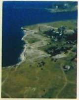
Aerial Photograph of Preserve, circa 1920 (Medvedeva & Shereshersky 1996) |
|
Page 46,47 |
Phase I Plan |
|
Page 49 |
Vignette of Proposed "Library Garden" |
|
Page SO |
Vignette of Proposed Shoreline Promenade |
|
Page 52 |
Vignette Enlargement of Inner Campus Section of Phase I Plan |
|
Page S3 |
Plan Vignette of Prototypical Dacha Renovation |
|
Page 62,63 |
Phase II Plan |
|
Page 64,65 |
Phase III Plan |
|
Page 71-72 |
Bird's-eye View of Master Plan & Master Plan Site Section/Elevations |
LIST OF DIAGRAMS & TABLES
|
Page 22 |
Analysis of Existing Views & Activities |
(based on IKONOS Satellite Image) |
|
Page 24 |
Existing land Use & Preserve Access |
(based on IKONOS Satellite Image) |
|
Page 27 |
Existing Landscape Interventions & Existing Rainwater Collection |
(based on IKONOS Satellite Image) |
|
Page 30 |
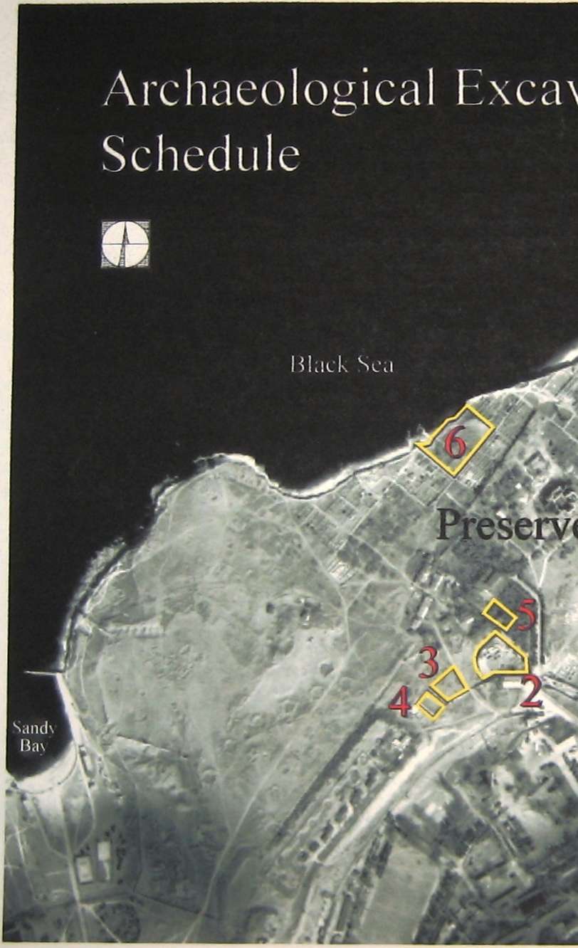
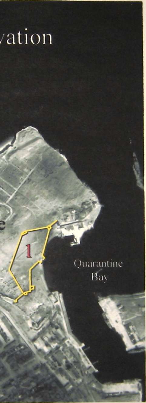
Archaeological Excavation Schedule |
(based on IKONOS Satellite Image) |
|
Page 32-33 |
Panoramic Site Analysis of Inner Campus | |
|
Page 34-35 |
Panoramic Site Analysis of Outer Campus | |
|
Page 36 |
Existing Black Sea and Quarantine Bay Shoreline Condition |
(based on IKONOS Satellite Image) |
|
Page 36-37 |
Panoramic Site Analysis of Perimeter/Shoreline | |
|
Page 38-39 |
Panoramic Site Analysis of Site Concerns | |
|
Page 40 |
Proposed Master Plan Program | |
|
Page 54,55 |
Phase I Preserve Areas | |
|
Page 56,57 |
Phase I Preserve Vehicular & Pedestrian Circulation | |
|
Page 58,59 |
Phase I Preserve Buildings | |
|
Page 68,69 |
Phase II & III Preserve Areas | |
|
Page 70,71 |
Phase II & III Preserve Buildings | |
|
Page 74 |
Master Plan Development Time Line |

• Background
• Purpose & Goals
• Methodology
INTRODUCTION
BACKGROUND
The National Preserve of Tauric Chersonesos, the Ukrainian Ministry of Culture, and the local government of the City of Sevastopol have collaborated with invited specialists to reach a consensus on the preservation and integration of the Ancient City within contemporary Sevastopol. Those plans are intended to allow the citizens of Sevastopol to enjoy the civic amenities and religious facilities overlaying the ancient fabric in ways that are constructive and will insure appropriate interaction with the monuments. That symbiotic presence will be structured to accommodate the growth of the Preserve's archeological mission. The U.S. National Parks Service Mission Report refers to the situation as "finding the balance between preservation and use." 1
Many scholars, past and present, have studied the Ancient City. There are selected excerpts of their various books, papers and design studies in the Commentary (Those documents can be found in their entirety in the Preserve Archive and Library). All offer valuable information on how the site has been treated over the centuries and what has been found in prior archeological expeditions. Along with the literature search. Llano Design conducted interviews of selected personnel within the Preserve's management group and design "charettes" sponsored by ICA in the summer of 2000. Those charettes included Ukrainian architects Nikolai Andrushenko and Tatiana Bazhanova, Director of the Chersonesos Excavation Stanislav Ryzhov; art historian Dr. Stephen L. Gavel, Director of The Ceres Foundation; University of Texas School of Architecture students Stan Pipkin, Seth Bossung, and Martha Kennan; and interpreter Svetlana Telenkova The design analysis and design proposal are based on those past studies found in the Archive/ Library of the Preserve, past work sponsored by ICA, and this campaign's interviews and design charettes. The ongoing geographic research of Paul Lehman and Carlos Cordova was also invaluable in our efforts.
PURPOSE & GOALS
One of the purposes of this publication is to assist the local authorities in persuading governmental organizations to facilitate the transfer of ceded land formerly used by military institutions, to seek legislative protection from urban sprawl, and to seek specialized technical consultation on issues like shoreline protection and other expert assistance in the Ancient City and Chora. Other locations around the globe have struggled to mitigate the effects of urbanization on ancient cultural fabrics, and it is hoped this document will encourage offers of comments, suggestions, and assistance. Those organizations and governments may volunteer their advice and share their experiences with the Ukrainian authorities once the urgency of Chersonesos' situation is more widely known.
In his presentation, "Preserving the Global Cultural Heritage in Post Cold War Ukraine," presented at the international conference, Art, Antiquity, and the Law: Preserving Our Global Cultural Heritage, (Rutgers University, October 31, 1998) Leonid Marchenko, Director of the National Preserve of Tauric Chersonesos, outlined the following goals:2
• Realize the full potential of the National Preserve of Tauric Chersonesos (Ancient City, Museums and Chora) as a world class cultural institution.
■ Increase urgently needed storage space for finds.
• Upgrade environmental controls and display facilities of existing exhibit buildings.
• Conserve the monuments under the Preserve's jurisdiction making them accessible to the public.
• Make Chersonesos' preservation a pilot project for the rest of Ukraine.
• Re-excavate and excavate new sites in the urban center to reveal more clearly the urban fabric of this "Ukrainian Pompeii".
• Develop the Library and Archive.
[For complete text, see www.utexas.edu/research/ICA/pubs/Leonid/index.html]
In the last two years additional items have been proposed as steps to achievement of the prior stated goals. The proposals are:
• Establish an international archaeological field school.
• Construct a new pottery and conservation laboratory.
Leonid Marchenko's paper broadly outlines the program of this master plan. The outline, while concentrating on the specific needs of Chersonesos, anticipates the potential utilization of the lessons learned across the whole of Ukraine. The U.S. National Parks Service Mission Report (October 2000) by Brooke Shearer and Destry Jarvis observes that currently 4% of Ukrainian land is set aside in parks and reserves managed by the government and that the Verkhovna Rada (legislature) has voted to increase that to 15% by the year 2015.3 In light of this four-fold growth, the precedents established at Chersonesos and its chora could well shape the character of the Ukrainian Parks & Reserves Program with respect to cultural resource management and development of sustainable tourism.
In addition, the Preserve must, out of necessity, become an example of the artful syncopation of divergent public usage patterns that have been in conflict. In an interview given to Prof. Jeffery Chusid of the University of Texas School of Architecture, Galina Nikolaenko, Deputy Director of the National Preserve of Tauric Chersonesos, reported that there are 400,000 inhabitants in the Total Administrative Area of Sevastopol and, of that, 300,000 live on the Heraklean Peninsula.4
Such population density will make the demand on civic amenities like parks and shoreline increasingly problematic. With at least one thousand meters of usable shoreline, the Ancient City is a prime destination, especially with its proximity to the city center.
The recreational demand for the Ancient City's shores is equaled by the religious demand for the modern structures above its acropolis. St. Volodymyr's Cathedral, the former monastery surrounding it, and the Uvarov Basilica are sacred to the Orthodox Church. The basilica is honored as the birthplace of Christianity in the Slavic World.5 As with the constant flow of swimmers, the flow of religious visitors cannot be obtrusively impeded. The master plan's goals include establishment of a new landscape of pedestrian circulation that uses existing and newly-created grade separations, along with revival of existing boundaries, such as the former monastery enclosure, to preempt points of conflict.
METHODOLOGY
Jeffrey Chusid outlined the conceptual basis for the current work in his 1998 report, "Preparing a Treatment and Management Plan for the Archaeological Park in the National Preserve of Tauric Chersonesos." That document prescribes an eleven-phase process for development of the Preserve's treatment and management plan. The terminology used in the report is derived from current policies of the US National Parks Service pertaining to Cultural Landscapes. The phases are:6
Research
1 Site Surveys and Inventories
2 Site History
3 Statement of Significance and Thematic Context
4 Condition Assessment
5 User Needs and Interpretive Plan
Designing the Project
6 Establishing an Appropriate Treatment
7 Developing Management and Maintenance Plans
8 Developing Alternative Designs for the Preserve
Implementing the Project
9 Creating an Economic Development and Fundraising Plan
10 Implementation
11 Post-implementation Review and Modification
The procedure recommended allows the work to proceed from the known to the unknown in a methodical and repeatable fashion. This is important if Chersonesos is to serve as a pilot project for the rest of the country. Included in the documentation from the 1998 campaign was the Masters Thesis of Gina Crevello, which
presents a formal Statement of Significance for Chersonesos and its Chora.7 It also outlined current maintenance and management policies.' The terms treatment, management, and thematic context are identified by Jeffery Chusid's report as being critical to define in strictly local terms. Once defined, those terms illuminate the paths that preservation efforts should follow. The definitions we have gleaned from our design charettes and interviews of critical staff members with respect to each of the critical terms follows: 9
Treatment: The local experts agree with the recommendation of Jeffrey Chusid, "treat... large portions of it (the preserve)... the same so that visitors are never confused between new and historic, speculative and factual." The first two of the six treatment classifications protection and stabilization are obvious needs of all ancient city and chora monuments endangered by urban encroachment, wave erosion, foot traffic, and neglect. They must become the first actions taken across the preserve. Subsequently, the remaining forms of treatment preservation, rehabilitation, restoration, and reconstruction happen at each location within the preserve in a site-specific fashion. Stanislav Ryzhov, Director of the Chersonesos Excavation, and Ukrainian architects Nikolai Andrushenko and Tatiana Bazhanova, summarized current Preserve intentions in discussions regarding the following example locations:
• Standing archaeology of Ancient City and Chora: the Preserve has chosen "Preservation "for the Chora and Ancient City [see Gina Crevello S work], which "maintains the site essentially as found, except for changes required to keep the site from further deterioration."
• Monastery & Subsurface Levels of WWI Artillery Battery: the Preserve has chosen "Rehabilitation "for the monastery & subsurface war monuments which "adds new uses or modern requirements for current uses, but maintains as much of the historic fabric as possible in the condition it was found "
• Surface Level of WWI Artillery Battery - the Preserve has chosen 'Restoration' for the surface levels of the WWI Artillery Battery, which "brings the site back wards in time to a period deemed significant in the history of the site."
• Proposed Recreation of Ancient City Blocks - the 1994 master plan, "General plan of the Preserve: Chersonesos site of the Ancient City " proposes "Reconstruction of Ancient City blocks in place which "involves recreating a historic site which has disappeared " (Note: Tatiana Bazhanova, Nikolai Andrushenko and Llano Design propose the reconstruction occur outside the limits of the Ancient City on the territory to be abandoned by the military)
Management: The Preserve should use the Pereyaslav example. The Preserve will enter reciprocal arrangements with local herdsman and gardeners to care for open space and rural monuments. By the creation of a teaching facility (the international field school), the Preserve will provide an ample opportunity for hands-on learning by apprentice conservators as a means of staffing the Preserve's monument protection, stabilization and maintenance program with a skilled labor force essentially, create a teaching center for restoration of damaged monuments and 16 artifacts. In all cases, the opportunity for subsequent re-evaluation must be maintained to the greatest degree achievable in the Ancient City and Chora.
Thematic Context: Stanislav Ryzhov proposes "to display the working organism of the city," allowing Chersonesos to be understood first from the point of view of its integrity as a city; allowing its various civilizations (Greek, Roman, Byzantine) to reveal themselves in a fabric where the periods are best preserved. The consequence of this is to allow "circumstances to dictate events" 10 in the presentation of the city. The city is revealed with its various epochs freely waxing and waning into and out of view. Time's "arrow" and time's "cycle" may be viewed simultaneously, as described in Principles of Archaeological Stratigraphy. "
Potential collaborators may include but should not limited to:
Scientific Research Institute of Architecture and City Planning of Kiev,
Nikitski Botanical Garden, Yalta
Institute of Biology of the South Sea, Sevastopol
Underwater Archaeology Center, Kyiv
Institute of Hydrophysical Research, Kyiv
Ministry for Environmental Protection, Kyiv
U.S. National Parks Service, Washington D.C.
U.S. Agency for International Development, Washington D.C.
World Monuments Fund
Packard Humanities Institute
Trust for Mutual Understanding
The Samuel Kress Foundation
The Brown Foundation
The World Bank
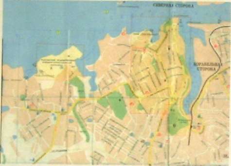
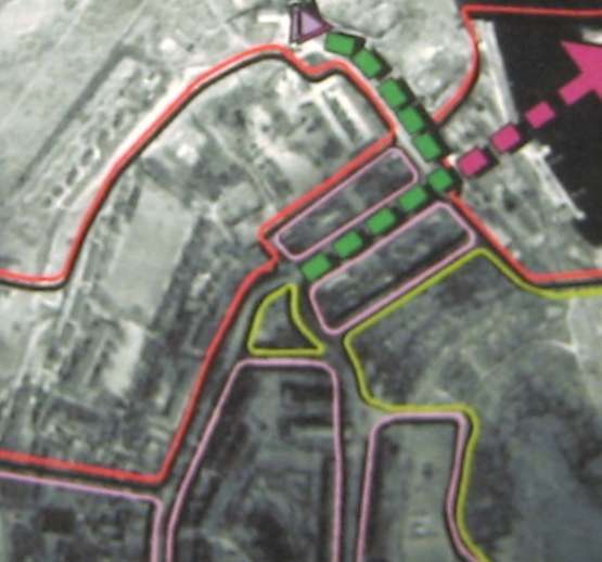
Map of Sevastopol City Center and Chersonesos.

Map of Chersonesos District with trolley bus routes shown in yellow.
ANALYSIS AND PROGRAMING
EXISTING CONTEXT
Chersonesos was founded as a Greek colony in the 5* century B.C. on the southwestern tip of the Crimean peninsula in the territory of the modern Ukrainian city of Sevastopol. The Ancient City covers approximately 33 Ha. It is part of a 10,000 Ha. Preserve, established by the Ukrainian government in 1994, containing the City and its Chora. Cherosonesos has an extraordinarily rich history and is one of the best preserved Hellenistic historical landscapes and Byzantine cities in the world. The Ancient City itself is largely intact and the surrounding chore's structure is evident. Both City and Chora existed for 1800 years before being overrun by the Mongols and abandoned in the 15* century A.D. However, as will be discussed later, the archeological monuments are endangered by modem encroachments and jurisdictional conflicts.
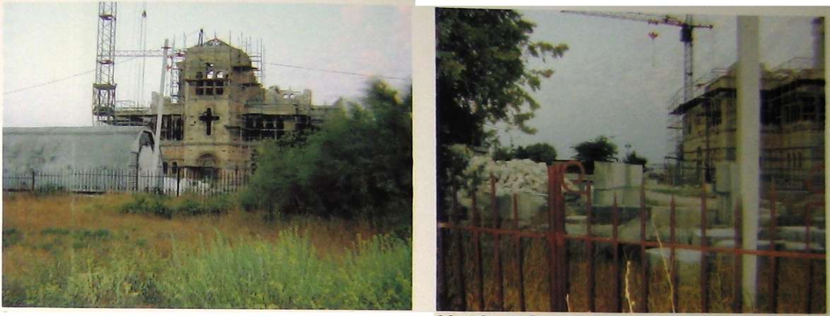
Chersonesos is also considered the birthplace of eastern Christianity, being the site where Prince Volodymyr of Kievskaya Rus was reputedly baptized.12 The Orthodox Church has a strong and long-standing interest in the territory of the Ancient City. The Church's aim is the restoration of the Cathedral and has shown little interest in the preservation of monuments from preceding periods.
Due to the strategic importance of its harbor on the Black Sea, modern Sevastopol (founded in 1783 by Cathrine the Great) has played a major role from the Crimean War to WW II. As such, Chersonesos conserves the sobering reminders of modern warfare as well.
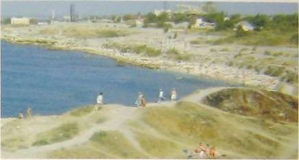
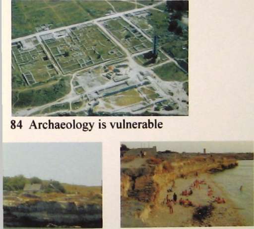
Currently, the Ancient City is threatened by continuous wave action from the Black Sea13 as well as the wear and tear of being a primary beachfront recreational area in a city of several hundred thousand people. Despite those pressures, Chersonesos is among the most complete and coherent ancient sites on the Black Sea. The successive layers of Greek, Roman, and Byzantine cultures are all present in the Ancient City fabric. In the remaining area of the Ancient City's territory, at least one of the three principal periods remains intact and, at some locations, all three periods are legibly woven together. Considering the current economic and political difficulties facing the Ukrainian people, the degree to which damage to this great cultural treasure has been avoided is remarkable.
Trends
• The appearance of the Ancient City has been in some areas physically altered by outside influences, principally warfare and coastal erosion. However, the Preserve's aesthetic integrity is still intact, and the views of surrounding areas afforded by the revetments enhance the visual appeal of the Preserve. (See Existing Views and Activities, p. 22)
Extended vistas
Offers potential for viewing the archaeology in conjunction with
itinerary signage so that Preserve visitors may orient themselves
Unsightly areas and activities
Vendors and restaurant activities
Squatters1 activities
Best Shoreline Views of the Sea
Disrepair bathrooms & unsightly military towers
Putative St Volodymyr baptismal font
Espadafla's vistas
77 Photo key
Sandy Bay'
• A considerable amount of non-Preserve related activity has penetrated its boundaries. These activities have shaped the atmosphere in both negative and positive ways. The presence
■ of squatters on the Preserve grounds mimic a larger trend throughout Ukraine. Recently, clergyman of the Russian Orthodox Church have used these tactics to temporarily occupy some of the Preserve buildings. There are also squatters that have established themselves in the Yacht Club on Quarantine Bay, the WWI Artillery Battery, and a small area between the Cathedral and Hologram Museum.
• The Preserve leases space to vendors and restaurant/café operators. They provide a service for the visitors and add a festive atmosphere to the Preserve. However, establishing certain building regulations and area limitations for the operators will maintain an architectural cohesion and help preserve the integrity of the Preserve grounds.
• The city of Sevastopol has a mass transit system that a large portion of the population uses. Additionally, the city is admirably pedestrian oriented. It would be a shame not to recognize this positive aspect in the Preserve Master Plan. Capitalizing on the transit availability would improve Chersonesos' relationship to the modern city center.
• Sevastopol is experiencing a very active period of renovation and new construction. Some of those changes happen at such a rapid rate that city services cannot keep pace with the growth. The expansion problems are particularly acute in the area of the Ancient Chora. Owner-built cottages (dachas) are constructed in previously open land. Recent changes in land ownership rules have permitted occupants but not sewer service. Water is delivered once a week by truck. The Sevastopol Administrative Area Planning organization is responsible for city planning. This body has a general plan for the expansion, but resources to support the required infrastructure have not materialized. Current plans call for construction of a bridge across Quarantine Bay that would bring more rapid access to the city center for Chersonesos and the surrounding district. Based on the assumption that resources will continue to be limited, the Preserve must encourage the city planners to reconsider the current situation to avoid an under-funded, hastily constructed, and unattractive bridge. In addition to its impact on vehicular traffic, the bridge, if badly designed, will sever the planned pedestrian connection between the Ancient City and associated archaeological remains at the eastern end of the bay. Those bridge designs should be prepared in careful collaboration with the Preserve. The future of Chersonesos, as
Pedestrian access to the Preserve property
I. Access created by the Preserve
2 Access created by the swimmers
3. Marine access from Quarantine Bay
Proposed bridge by Administrative Area Planners
Green Belt
Military Base
Preserve's current entry drive

И x
well as the convenience of the modern city, must be considered.
• At present, landscape materials for green belts and public spaces are supplied by a system of state operated nurseries. These nurseries are subdivided into groups. One nursery supplies only trees and large shrub-like trees. Another supplies shrubs and certain ground cover, while another concentrates on flowering annual and perennial plants. Knowledgeable personnel a mixture of bio-engineers and horticulturists staff these nurseries. They are active in searching for and propagating new plant materials. However, they are limited by their facilities. Unlike private sector nurseries that have a stock of plant material inventoried for sale, the state-owned nurseries only stock material previously ordered and do not maintain an inventory. State nurseries grow the plants only after an order is taken. Privately-operated nurseries have not developed in the Crimea.
Users
Although the Ancient City and immediately adjacent areas of the Preserve cover approximately 200 acres of land, they are still overwhelmed by the volume of users. The users fall into three major groups: religious visitors, Preserve and Museum visitors, and recreational visitors/swimmers.
In the past, the Preserve administration has charged admission to those who enter in order to use the Cathedral. Due to the Cathedral's placement, religious visitors must enter the Preserve grounds to access the Cathedral. On the other hand, the Preserve would lose revenue if it did not charge admission to everyone passing through the gates the truly devout and the unscrupulous gatecrashers on their way to the beach cannot be differentiated. In addition, the Preserve administrative staff is in a constant battle to prevent the illegal occupation of parts of the Ancient City by the Russian Orthodox Church's hierarchy. This parochial faction has exhibited aggressive behavior in the past.14 To clarify, it is not the local parishioners, but the local and regional clergy of the Russian Orthodox Church who have instigated confrontations over the territory of the Ancient City These past confrontations have created an adversarial climate which impairs the ability of all parties to resolve issues associated with the paying of Preserve admission fees by religious visitors.
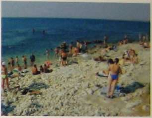
The recreational visitors and swimmers are a mixture of local people and tourists They provide revenue and a festive atmosphere to the Preserve However, their random foot traffic contributes to the deterioration of the ancient structures and to the erosion of the landscape. The swimmers often traverse the ancient structures to
access the shoreline. There is a complete lack of amenities for the recreational visitors. The ancient structures suffer when the visitors are unable to find a restroom or changing area. Since many swimmers enter by climbing in from the adjacent public beach at Sandy Bay or from the non-guarded southwest entrance gate, little Preserve ticket revenue would be lost if the swimmers were barred. However, if their impact on the monuments could be avoided, the Preserve could generate dependable revenue from licensing vendors who provided concessions to the swimmers.
Each group has needs which conflict with the needs of the remaining two groups. Those conflicts can be resolved by:
1. Changing parts of the existing layout of the Preserve.
2. Providing amenities that are currently absent.
3. Changing operational tactics of the Preserve.
However, the Preserve has a larger task: the need to increase operational funds in order to effectively implement those strategies and address the problems outlined below.
Maintenance
Victor Streltsov, Deputy Director of Operations, has divided the Ancient City and Preserve into three sections. Three retirees throughout the year, who receive help in the summer from two extra retirees, maintain these sections. Mr. Streltsov alone handles any maintenance problems that occur in the buildings. This is clearly an insufficient number of people to maintain the grounds and Museum (which includes two exhibition buildings, storage facilities and laboratories). Because of the lack of funding for attendants, the whole facility has deteriorated. Hie Preserve must find alternative means of providing staffing for she maintenance and policing until conventional monetary resources can be generated.
The lack of conventional resources has allowed the Preserve to invent some productive alternative maintenance systems. One policy allows local farmers to graze or harvest the large grass areas that exist within the Chora and Ancient City grounds. Another policy allows staff to tend an informal propagation garden that supplies the decorative planting for the flower beds the Preserve has kept active (See Existing Landscape Interventions, p. 27).
Utilities
The interna], overhead electrical distribution system is unattractive, in disrepair, and lacking sufficient capacity. The electrical lines are awkwardly placed throughout the preserve with little consideration to the aesthetic impact. The primary distribution from the municipal grid has sufficient capacity if properly distributed, but that source has been highly unreliable. This latter problem was addressed by
the Institute of Classical Archaeology in 2000, with the installation of a generator to supply backup electricity to the administration building. Archives, Byzantine Museum, and Library.
Water lines are randomly placed on the surface of the ground throughout the Preserve creating hazards to pedestrian traffic. Victor Streltsov reports that Preserve planting beds are irrigated by hand hose spray from only three hose bibs in the vicinity of the Byzantine Museum. Areas out of reach are irrigated by bucket. The dormant rainwater storage cisterns of the former monastery still remain and appear to be repairable. The use of portable, submersible pumps would allow the cisterns to immediately improve irrigation distribution without any further disturbance to the cultural layers. Plumbing must to be modernized to handle the amount of visitors entering the Preserve and to allow room for expansion.
Amenities
The Preserve lacks provision for the comfort and safety of the public:
proper pedestrian lighting trash containers drinking water fountains directional and itinerary signage
adult, child-size and handicap accessible furniture (benches and tables)
The Preserve lacks operational amenities:
sanitary facilities are inadequate and hygiene is substandard handicap accessibility is limited
no dedicated service area to maintain the Preserve grounds and facilities.
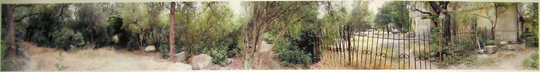
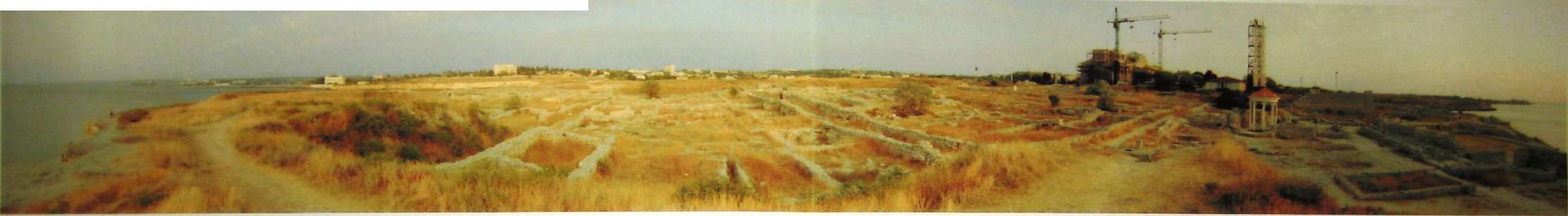
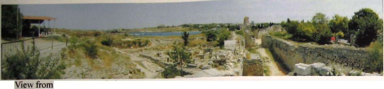
SITE ANALYSIS
For the sake of the reader, the analysis section has divided the Preserve into three areas: the first is called the "inner campus," which includes the enclosure of the former monastery and encompases the Ancient Acropolis, second is the "outer campus," which includes the remaining territory of the Ancient City, the third component is the interface with the Black Sea and is called the "perimeter/shoreline."
ENLARGED VIEW OF EXISTING INNER MUSEUM CAMPUS
A Cathedral & Cloister
B Administration & Byzantine Museum
C Greek & Roman Museum
D Ancient Theater
E Ancient Mint
F Fundi
G Conservation & Restoration
H Office Space
I Hologram Museum
J Staff in Residence
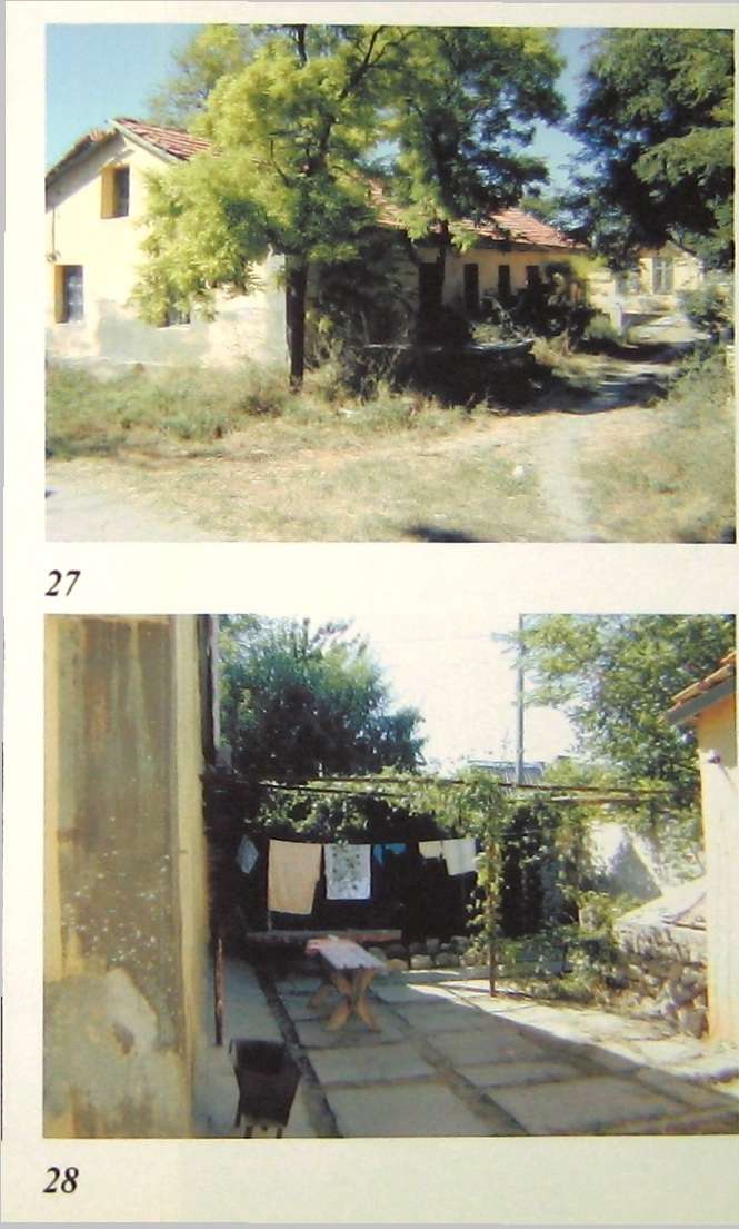
K Dacha
L Storage Barn
M Chapel
Inner Campus
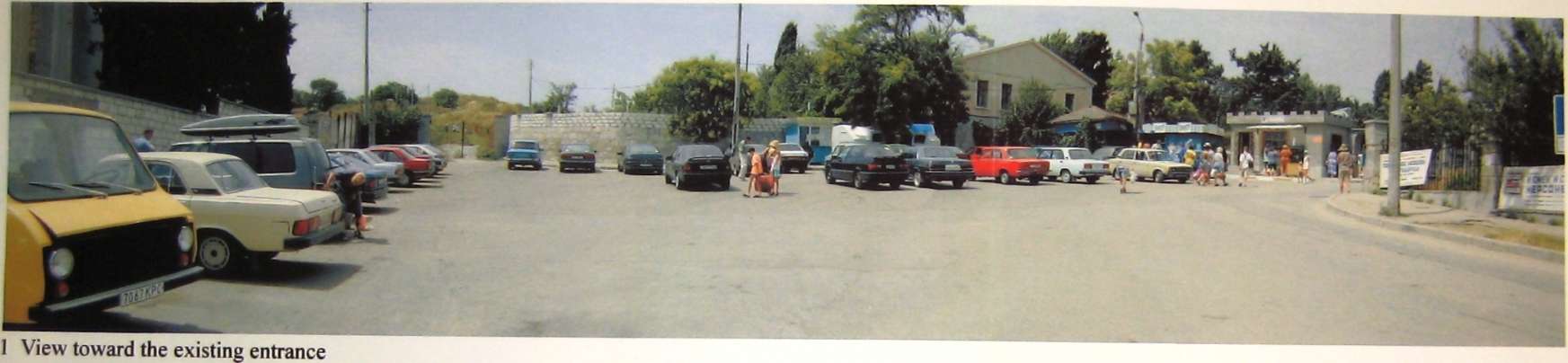
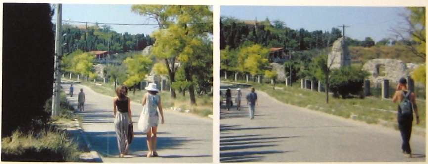
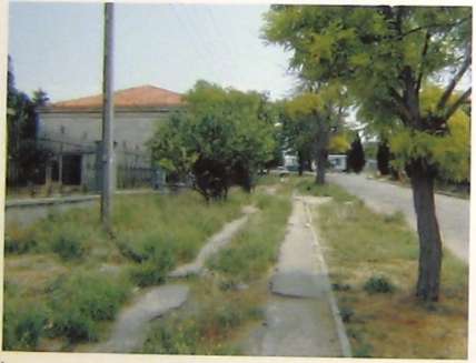
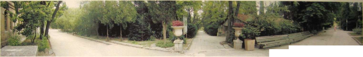
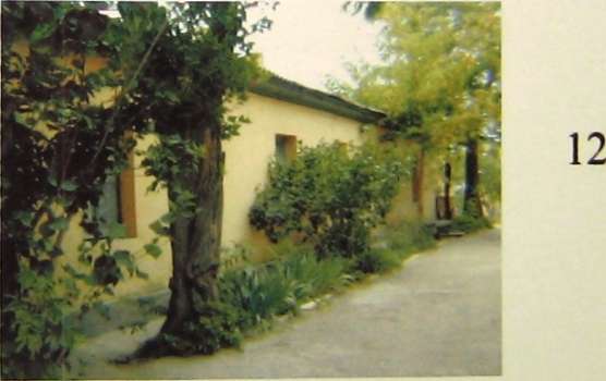
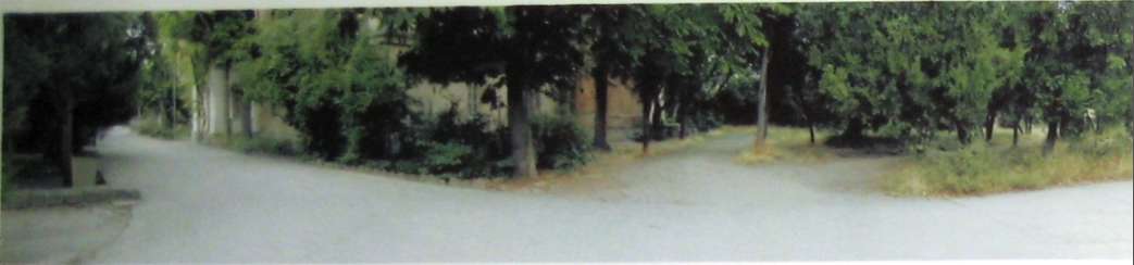
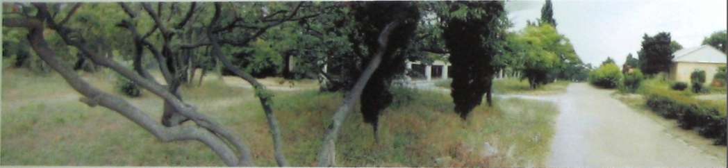
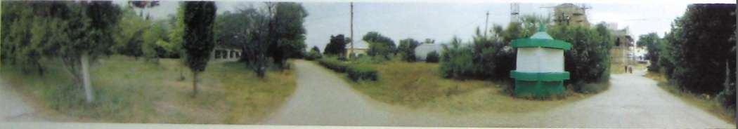
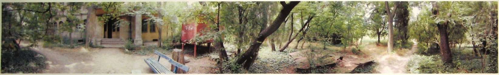
When approaching the entrance of the Ancient City, visitors will find the north-south section of Drevnyaya Street used primarily as a pedestrian thoroughfare occasionally interrupted by cars. Walking is the primary mode of transportation for residents of Sevastopol. The sidewalk along Drevnyaya is seldom used—people prefer to walk on the street as it is in better condition and it is wide enough to allow visitors to walk in groups (see picture 1). The existing sidewalk is too narrow, broken up, and offers no shade. The fence along Drevnyaya Street, while providing security to the Preserve and the required protection from falls into the excavated area beside the City walls, could be lighter in appearance and less of a visual barrier. The northern end of Drevnyaya Street is a widened paved area in front of the current entrance to the Preserve territory. That entrance once served the former monastery. Unfortunately, the only parking is located at that entrance, causing conflict between vehicular and pedestrian traffic. The cars detract from the entrance's visual appeal and reduce pedestrian safety when traffic is heavy.
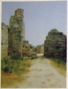
After purchasing a ticket to enter the Ancient City, a visitor moves along a service drive lined with trees. This drive remains active throughout the day with vehicular traffic related to the operation of the Preserve. The current combination of service drive with pedestrian entrance is uncomfortable and unfocused. As on Drevnyaya Street, pedestrians are in conflict with vehicular traffic diminishing the entry experience. The service drive eventually leads to a collection of trees adjacent to the east face of the main Museum building, the Byzantine Museum. The visitor must search for a starting point because the entry drive has led away from major archeological structures, the Ancient Mint and Theater (see pictures 2-5), and Greek and Roman Museum exhibits. The small earthen paths and sidewalks leading to the Mint and Theatre are indirectly connected to the entry/service drive and are virtually invisible. Those ancient structures should be a primary part of the entrance sequence of the Preserve.
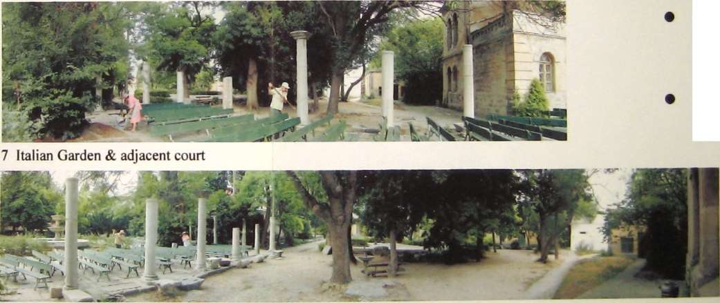
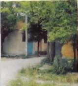
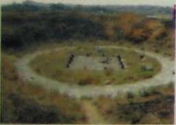
The placements of the old monastery buildings define an assortment of courts in various sizes. The main courtyard, the "Italian Garden" (see picture 6), is bounded by the Ancient Mint, the Byzantine Museum (the former rectory of the monastery), the chapel and a line of free-standing columns recovered from the area Ina Antonova, Museum Director from 1955 to 1989, installed the garden for Nilrita Khrushchev's visit in the early 1960s. The garden is composed in a manner appropriate to its current function as entry court to the Byzantine Exhibit, however, it is handicapped by the placement of benches that interfere with pedestrian movement. The fountain, pavement and the planters need major restoration. Because of its historical significance, the Italian Garden should be emphasized. The scale of the fountain will allow it to be viewed from a great distance if the current arrangement of view obscuring vegetation was revised.
The two courts (see pictures 7-11) adjacent to the Italian Garden lack character
1 Ancient Port
2 Ancient Theater
3 Ancient Baths (Therma)
4 Ancient Water Reservoir
5 Ancient Mint
6 North central area
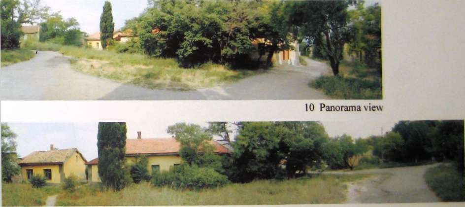
The courts' edges are defined by the four fondi (storage areas in monastery buildings), the chapel, the conservation building and the west storage sheds The north/south walkway between the chapel and conservation building separates the two courts. The main public restroom, located in the eastern court, is awkwardly placed and poorly built The eastern court is congested with random tree planting, dissected with random pedestrian paths, and punctuated with oddly-placed objects. However, because of their location, the courts have potential. They could become pleasant areas for seating, outdoor presentations, exhibition of mosaics, traveling outdoor exhibits, and an extension of the Italian Garden. The surrounding buildings' placement and scale create a comfortable enclosure. The buildings' arrangement yields glimpses of the outer campus. Those views entice visitors to proceed beyond the enclosed courts to the excavations outside. The plant material needs to be reorganized and stronger trees should be planted. The tree replacement will need to be carefully planned so not to leave the grounds bare during the transition. Emergency access and other functional considerations must also guide renovations.
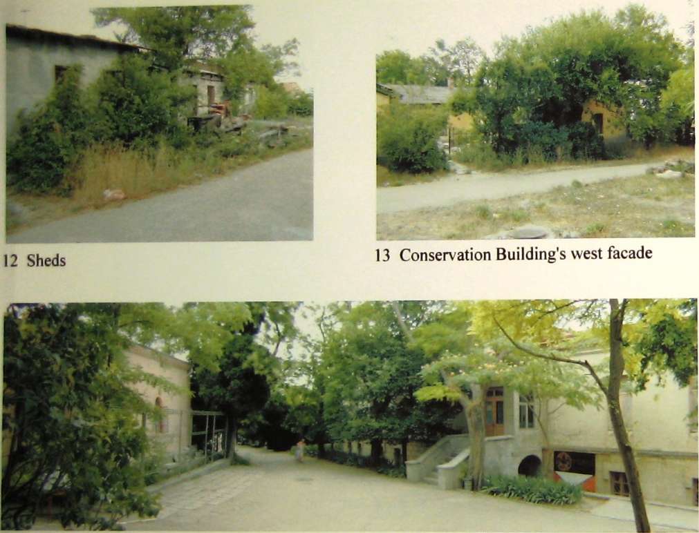
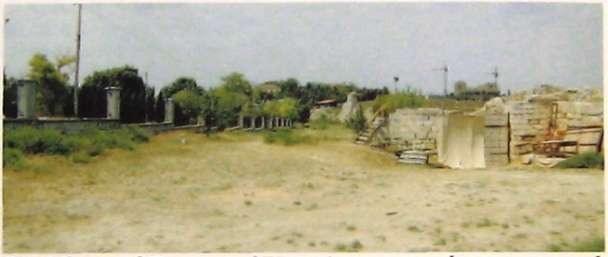
Expansion space on the Preserve grounds is very limited in order to protect the cultural layers. The area between the existing conservation building and west storage sheds should be investigated as a means of expansion for the Preserve facilities. The space is currently used for service and is not part of the pedestrian circulation pattern. The sheds are in poor condition and soon will only be partially usable. There is potential to merge rebuilt sheds, the courtyard of the conservation building, and the open service space between into a work court. The new work space would maximize the use of the existing indoor and outdoor spaces of both buildings. The court would allow the visiting scholars, Preserve staffs and students to work in a secure area adjacent to, but isolated from, the Preserve's public visitors (See pictures 12 & 13).
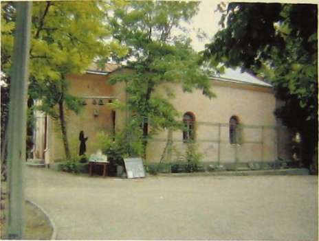
The walkway between the Chapel and Conservation Building allows visitors to circle back toward the Greek and Roman Museum (the former refectory of the monastery). It also can act as a container of processions related to Chapel activities. The triangular space between the Chapel, Conservation Building, and the Greek and Roman Museum should be used as the entry court for the Greek and Roman Museum. The court will serve both the chapel and the Greek and Roman Museum. (See pictures 14-17). The existing trees should be trimmed high, paving made more cohesive, and the odd metal scaffold removed The southern facade of the chapel should be the courts focal point because of its wonderful rose color and orientation toward the sunlight. The chapel's stepped foundation makes excellent seating and may also be used to exhibit amphorae, pithoi, and other large ceramic objects. The court should be simple in its planting and other outdoor elements Pedestrian lighting would further enhance the space
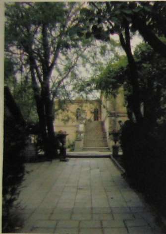
The largest area defined by the monastery building placement lies between the two largest buildings, the Byzantine Museum and the soon to be restored ruin of St Volodymyr's Cathedral (see pictures 18-20). The area is fragmented by random
tree planting and broken into a collection of small spaces loosely organized along the main seaward pathway. The disjointed collection of small spaces is incompatible with the grand scale of the structures to either side. At present there is little visual connection between the buildings, although the architectural connection is strong. The architectural connection, grand scale, and similarity of size are potentially the basis of a grand open space. Such a space would have similarities to the ancient agora buried nearby. The Cathedral should be made part of the Preserve visually, but kept functionally separate with the use of a light fence. The religious visitors would be able to use the Cathedral without disturbing the operation of the Preserve or visitors to the Ancient City.
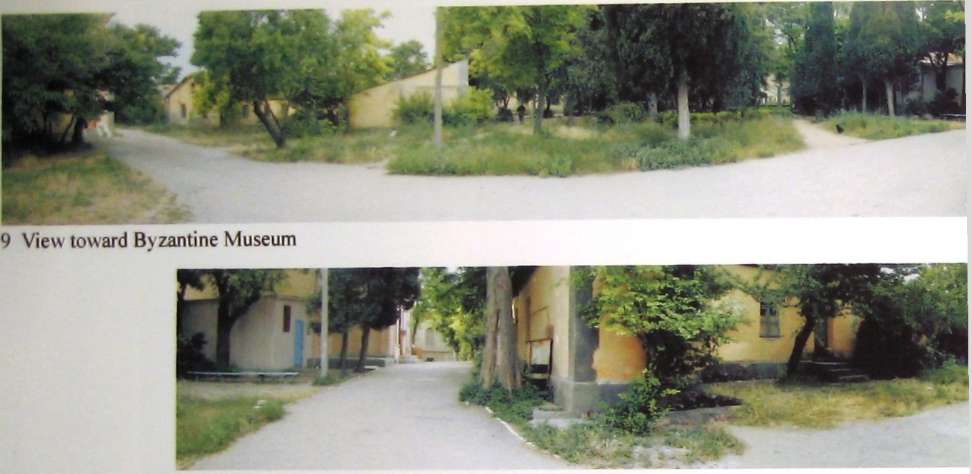
While many outdoor spaces must be interpreted as gardens or courts, the Kitchen Garden was established as part of the monastery. The garden is located north of the Byzantine Museum (See pictures 21-24). The garden is overgrown and it is probably one of the most abandoned areas. It has been divided into two areas. The area adjacent to the mosaic exhibit shed has been landscaped to screen it from the remaining garden. This area is used by the Preserve to grow seedlings for the planting beds. The facility was created by the initiative of staff members Raisa Tychinnskaya and Vera Kruck, who have taken it upon themselves to collect flower seedlings from their neighbors and propagate plant material. They have also managed to build a small green house to provide a potting and planting area. Their activities are a response to the lack of grounds maintenance funds, which is a problem common even at the world-famous Nikitski Botanical Garden in Yalta.
The other portion of the Kitchen Garden has become a service area. A rusted metal water tank has been placed in the middle of the garden and utility conduits litter the north facade of the Byzantine Museum. There are also exposed water lines running along the surface of the ground throughout the garden. The perimeter masonry wall is in poor condition and the once decorative iron fence is now scrap metal. The old cistern has been abandoned and is sealed with a rusted metal lid, which is now unsafe to walk on. The garden has become overgrown and is seldom used due to lack of daylight and amenities. The abandoned garden has great potential because of its location between the wonderful view of the sea at the former monastery wall and what could still be a stately north facade of the Byzantine Museum. The upper floor of the main building would afford excellent and simultaneous views of the garden and sea.
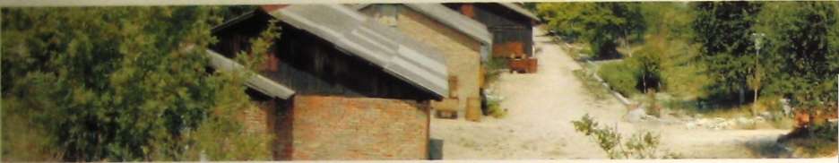
The Preserve fondi are to the west and adjacent to the Kitchen Garden. The arrangement of the fondi buildings produces small outdoor courts in the spaces between buildings. Those areas are currently used as yards by the Preserve. Because the fondi are concentrated in relatively small area, it would be easy to separate the fondi and the spaces between from Ancient City and Preserve visitors. The spaces between buildings would become outdoor work areas for the visiting scholars, archaeologists, and Preserve staff. When fenced, the courts would enhance the security of the fondi (See pictures 25-28) 32
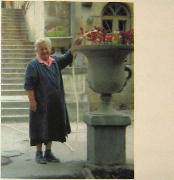
Raisa Tychinnskaya watering plants near die Byzantine Museum
1 - Existing entrance & Drevnyaya Street approach
• Parking should not interfere with entrance
• Pedestrian and vehicular circulation should be separated
• Use of an ancient entrance at the Tower of Xeno will create a grand entry to the Preserve
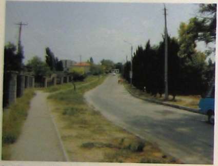
View of Drevnyaya Street from the existing entrance
1 View down Drevnyaya Street toward Preserve's existing entrance
2 Ancient Theater panorama
2 & 3 - Ancient Theater with Temple & Ancient Mint
• Existing Preserve's sidewalks border both the Ancient Theater & Mint. At present, those walks are orphaned by the existing circulation pattern being left out of the current entry sequence
• These important ancient structures should
be incorporated into the entry sequence of the Preserve
3 View of Ancient Mint facing Italian Garden
3 View of Ancient Mint from border sidewalk
4 - Existing walkway adjacent to Ancient Mint
• The walk leads your eye dramatically to the Byzantine Museum's gallery entrance steps
5 - Existing walkway along the Byzantine Museum's south facade
• The walk is an opportunity to create a spine-like corridor connecting activities throughout the preserve campus
• The existing walkway follows an ancient road alignment and frames the view of St. Volodymyr's Cathedral. That view exposes the slight misalignment of the walkway and the
Cathedral, highlighting the distinction between ancient and later geometries
5 Panorama of the walkway along the Byzantine Museum's south facade
4 View toward Byzantine Museum's gallery steps from walk adjacent to Ancient Mint
5 View of St. Volodymyr's Cathedral from walkway in front of the Byzantine Museum's south facade
• Fountain and stone pavers need to be repaired and refinished
• Benches should be relocated during regular operations to allow smoother circulation of large visitor groups, but placed nearby for special occasions
• Existing Italian Garden layout provides the flexibility required to accommodate use by groups of various sizes

6 Italian Garden
6 Talent show in Italian Garden
7 & 8 - Existing adjacent court to Italian Garden
This area could serve as an extension of the Italian Garden. The additional space would improve the circulation of large tour groups
Currently this area is spatially fragmented, being dissected by colliding streams of circulation and awkwardly placed objects Mosaic display should be in the sunlight for optimum viewing
8 Italian Garden & adjacent court with mosaic display

8 Mosaic display in the shade
11 Panorama view
9 & 10 - Area between the Chapel, 'Fondi' and Conservation Building
• Has the potential to become a transitional courtyard node for the various surrounding buildings
• Has potential to become the focal point for the pedestrian circulation and to organize converging external spaces
15 Area between Chapel and Greek & Roman Museum
14 Approach toward Chapel
17 Existing Inner Campus Areas
• Positions of the existing buildings create smaller courtyard areas
• These "courtyards" should be developed as entry courts to the various buildings

17 - Chapel entrance
16 Conservation Building's east facade
18 Panoramic view toward Byzantine Museum
19 Panoramic view toward the sea
20 Panoramic view toward the Cathedral
20 Area between Byzantine Museum & Cathedral
• Spatial cohesion between the main buildings is lacking
• Broad views and large buildings could support a court of grand scale
• Improve the visibility of recurrent architectural themes, increasing unity among elements of the landscape

21-24 Byzantine Museum's "kitchen garden"
• Has potential to display spoli in a garden setting j
• Has incredible views to j the sea from the balcony; and the grounds
• Because of the many views offered by the architecture, more extensive garden development would be worthwhile
• Should not be used as a location for utilities or storage
21 Side view of Museum's west facade
22 View of Museum's north facade
framed view
24 View of fallen "kitchen garden" wall adjacent to fondi' storage
23 View of gate leading to the sea


• Has potential to develop into a nice outdoor work complex for archaeologists & museum staff members
• Helps delineate the inner campus area
31 West facade
32 View of south Cathedral yard
30 View from east facade

29 East facade

29 - 34 St. Volodymyr's Cathedral
The area between the Cathedral and the northern remnant of the monastery wall could command unobstructed views to the sea similar to the Kitchen Garden. A collection of overgrown shrubs, sheds and other buildings are scattered upon the ground without orientation either toward the Cathedral or the sea. Elimination of the derelict buildings and orientation of the remaining building toward the Cathedral will expose the full length of the former monastery wall as a banister from which to view the sea and the Roman ruins just on its other side. Those modifications would give the north apron of the Cathedral an uncluttered view of the seashore similar in expanse to the view its south allows of Sevastopol. (See pictures 29-34)
Outer Campus
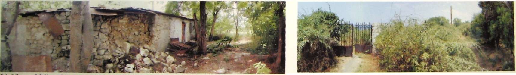
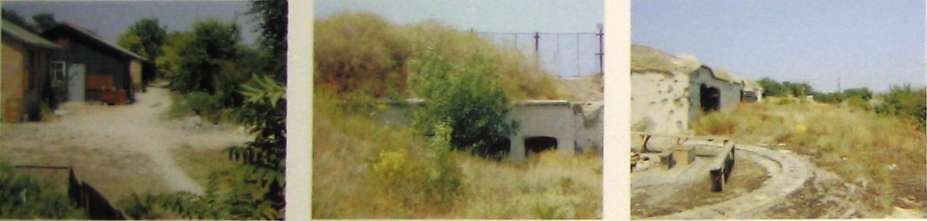
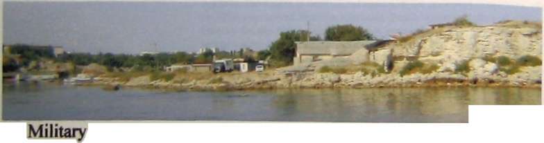
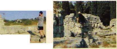
The southwest corner of the ancient territory's outer campus contains WWI structures, in addition to ancient remains (See pictures 35-41). The Artillery Battery served to defend Sevastopol during WWI. There are still remnants of the revetments that held the artillery and munitions. According to Tatiana Bazhanova, Nikolai Andrushenko, and Stanislav Ryzhov, several levels of barracks and munitions magazines are hidden beneath the artificial berm. The south side of the berm shelters bunk houses that are now being used by the Preserve as housing for scholars and students. The buildings are in disrepair and the utilities are substandard. The top of the berm sits approximately 25 meters above the elevation of the Italian Garden. There is one residence at the east end of the complex, granted homestead status in the early stages of land ownership reforms. In providing cohesiveness to the Preserve grounds, it is recommended that the residents be offered appropriate compensation and provided with housing in another, mutually acceptable location. The Artillery Battery is generally intact with only the cannon, cannon carriages, and munitions infrastructure missing. The overall massing of the work is complete and the revetments give wonderfully comprehensive views of the Black Sea, the Preserve grounds and nearby Sevastopol. It has the potential to become an outdoor museum of military artifacts, not the least of which is the artillery embankment itself. Presently, there is fencing that needs realignment to offer protection and be visually inviting and cohesive with the rest of the Preserve.
The archaeology of the west grounds of the Ancient City is not extensively exposed. The area presents itself as a rolling grassland meadow. The soils in this area are shallow with outcrops of limestone (see picture 42). There are definite patterns in the vegetation. Certain types or varieties of grasses group together in small sections of the rolling grassland. The visitors have dissected this area with a multitude of footpaths. Swimmers are primarily responsible for the paths. Also, the swimmers appear to be responsible for the campfires that occasionally burn out of control leaving unsightly patches of burned grass. This area is also grazed by local livestock and harvested for hay. It is sprinkled with bomb craters and abandoned machine gun emplacement bunkers. There is some exposure of the Ancient City
Wall, but not exposed to the extent of the eastern Walls. The western extremity of the Preserve grounds offers extensive views of the adjacent public beach, the Black Sea, the Museum, and the modern city. From Monastery Hill (see picture 48), the viewer gains a 360-degree view of the Preserve and its connection to the city and the sea.
The north central section of the Preserve 's archaeology is continuously exposed, except for a small section near the commemorative bell. This section is the most highly trafficked by visitors and swimmers. One of the more popular gravel beaches is located adjacent to that section of the Ancient City. The ancient structures are often used by swimmers changing into their swim gear. The swimmers have even built campfires in the ruins and the children use the remains like playground climbing equipment. Unfortunately, there is not enough staff to patrol the area. However, there are spots that allow one person to have an extensive view of large sections of the shore and the archaeological structures. Placing observers at those locations would provide complete surveillance of the territory with a limited staff (see pictures 58-62).
Along the main seaward walkway (near the grave of the museum founder) is a leased café which remains open late into the night These late hours encourage visitors and the swimmers to stay past curfew, encouraging destructive behavior by visitors. Pushcart vendors would seem more appropriate. The vendors could be ushered out the gates at closing time, like the visitors. The current vendor has installed exposed water lines and an arbor-like metal awning, which interrupts the view of the sea.
Northeast of the Cathedral, the ancient structures are also continuously exposed. Although the most appealing gravel beach is located in this area, the grounds are less vandalized by visitors. Perhaps the large difference in elevation between the preserve grounds and the gravel beach below is responsible. In fact, the swimmers have to climb down a steep, narrow stone stairway to access the beach. The less damaging traffic is mild enough to allow wild grass to establish itself among the ancient structures. The combination of the golden grass and the white/gray limestone of the ruins are very pleasing. (See picture 63)
The military's shore guide tower north east of the Cathedral is a visual disturbance in an otherwise placid area. An unattractive, modern, gazebo placed in 1997 above what is believed to be St. Volodymyr's baptismal site is not as disruptive as the guide tower, but its design is incongruous. The existing gazebo has no architectural relationship of the Cathedral's architecture or the archaeological remains. There is a public restroom located at the foot of shore battery berm. It is in disrepair and needs to be renovated for both health and aesthetic reasons. The top of the berm affords great vistas of the sea and Cathedral. It is an ideal spot for descriptive signage and an attendant to monitor the area.
35 View of base housing at the bottom of the berm
36 View of base housing 37 Storage niches 38 Gun emplacement

41 View seen from the top of the berm


39 Top of gun emplacement 40 View of Reservoir, Quarantine Bay, and gun emplacement structures
35 - 41 WWI Artillery Battery, "Base"
• Housing needs renovation
• Offers views of Sevastopol, Preserve, bay & sea
• Restoration of military structures can serve as an outdoor display gallery of war artifacts

43 View of the adjacent public beach
42 View of the Preserve's southwest perimeter stone wall

45 Partially excavated section of the ancient city wall 46 Partially excavated section of the ancient city wall


44 Swimmers climb down from the pier
42 - 47 Southwest Section of the Preserve
• Swimmers filtrate into the Preserve from the public beach
• This section of the Preserve is used as a back door entrance
• Unlike the center part of the Preserve, there is more visual contact with with the surrounding city
47 Gun emplacement
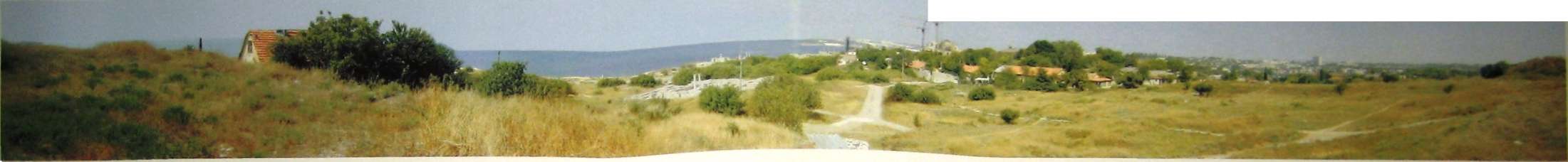
48 Panoramic view north from the top of Monastery Hill
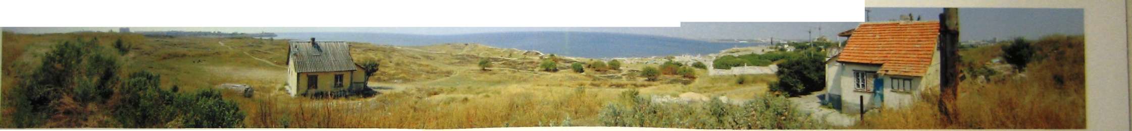
49 Panoramic view of the Black Sea from the top of Monastery Hill
55 Primary footpath 56 Partially revealed from southwest entry chapel remnant
57 Example of local grasses
• With excavation several decades away, the Preserve can stabilize the archaeology by using this area for the botanical study of native grasses
52 Spider web of pathways
53 Modern combat trench
• Swimmers do most of their damage in this area
• Central promenade's inland views allow a person to orient themselves within the landscape
• End of promenade is a convenient location for a Preserve attendant

58 Panoramic view from terminus of central promenade

61 View of archaeology from espadafia
59 View of shore below terminus of central promenade
60 Central promenade ends at gravel beach
62 View ot archaeology & remnant of Monastery wall
63 Panorama view from northeast militaiy berm
• The archaeology is partially excavated, potential for continuous exposure of archaeology is confirmed with the recent satellite photo
• Swimmers are not as abusive to the ancient structure

64 View of archaeology east of cathedral
66 View of east Preserve's grounds
65 Sunken military structure by yacht club
70 View of Tower of Xeno's east ancient gate and exterior Preserve's existing perimeter fence
69 Section of a rampart with a tower
68 Section of a rampart curtain XIX
71 Edge of Preserve's grounds by the Tower of Xeno
67
current entry facing east
• The ancient structure is one of the most prized ruins of the Preserve, unfortunately it is often used for theatrical productions that increase the wear and tear on the archaeology

Interior view, with seats used for plays
74 Tower of Xeno 75 Exterior view
73 View from the top of Tower of Xeno
The central eastern and southeastern portions of the Ancient City are not extensively excavated but, according to archival information and satellite photography, contain remains which are intact. The Cathedral's presence (see pictures 29-34) in the landscape dominates the area. The landscape to the east of the Cathedral is covered in wisps of long golden grass that reflect the setting sun at dusk. Birdcalls are audible in this region of the campus since it is removed from the sounds of surf and hundreds of swimmers. Unfortunately, the peaceful and pleasant views of the Cathedral and landscape are countered by the unsightly views of the Yacht Club and its surroundings. A group of people live in this area who keep livestock and tend small gardens. The Yacht Club has expanded to include a collection of storage containers appended to the existing building. There is not the proliferation of footpaths as in the western section of the Preserve because the swimmers do not approach the shore from as many directions. There are few swimmers in Quarantine Bay, minuscule in number compared to the. northern beaches.
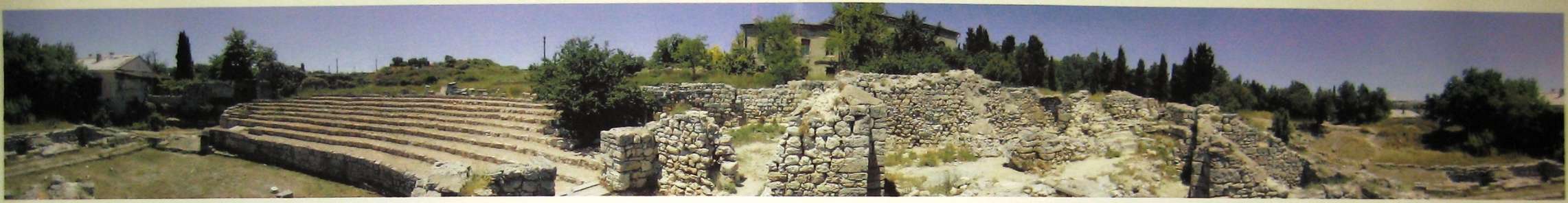
The City Wall (See pictures 67-75) is the Preserve's most striking ancient structure. In fact, it is the largest standing monument of antiquity on the Black Sea. Tatiana Bazhanova and Nikolai Andrushenko have suggested that the entry sequence begin at the City Wall entrance near the tower of Xeno [refer to appendix for their studies]. Visitors would receive a spectacular introduction through a structure used to enter the city over two millennia ago. The City Wall is stratified by cultural epqchs. The technology of each epoch left its mark, allowing the sequence of the various levels of Greek, Roman, and Byzantine to be seen along the entire length and height of the structure. The south end of the Wall shows signs of wear from the periodic theatrical performances held there. The supervision of the stage production techniques by a Preserve archaeologist is recommended.
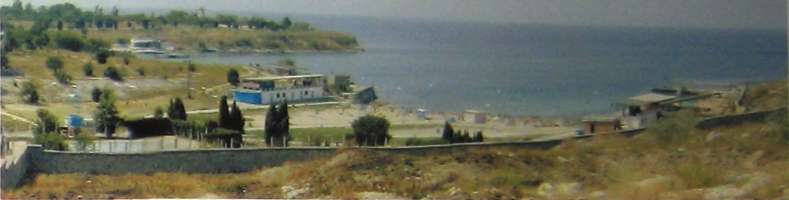
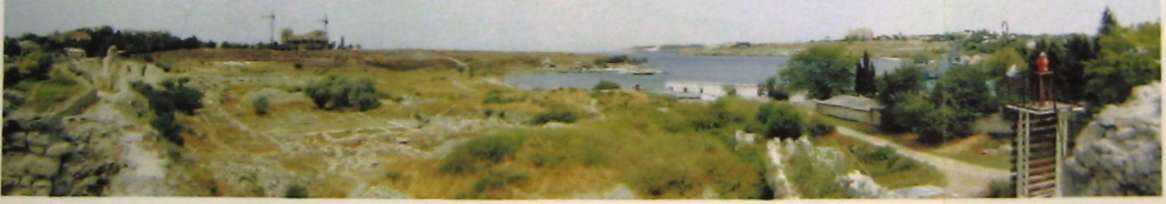
Perimeter Shoreline
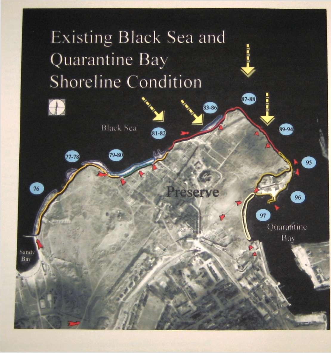
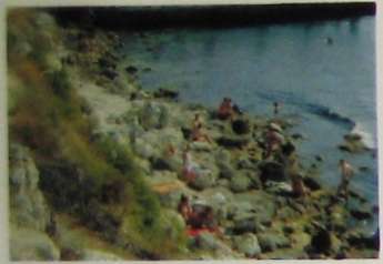
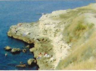
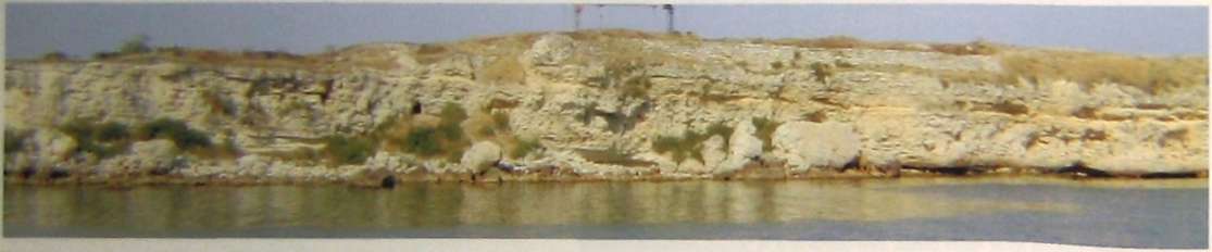
The north and east sides of the Preserve are bounded by the Black Sea, and half the south side by Quarantine Bay. Its shoreline is an important landscape element in the Ancient City's visual appeal. In general, the shoreline is very important to the local recreation. Swimmers use the Preserve shoreline 24 hours a day. The swimmers prefer to use the shore of the Preserve instead of the adjacent public beach at Sandy Bay. The public beach does not offer the natural form and wave action that the Preserve's shoreline possesses. Unfortunately, that beauty is also the source of the shore's congestion. The resultant pedestrian traffic exacerbates existing erosion problems. Expert marine ecologists and hydrophysical engineers are needed to stabilize the shoreline's ecosystems and structure. Portions of the shoreline are unstable and are eroding rapidly. Some of the monuments are in danger of falling into the sea.
The shoreline is comprised of several formations, including large, continuous bedrock platforms that are connected with smaller stone islands at its western extreme
Platforms
Endangered Cliff Edge
Critically Endangered Cliff Edge
Eroding Beach Shoulder Gravel Beaches
large gravel beach (first)
small gravel beach (second)
Area disturbed by past Military activities
Sand Beach
Destructive wave direction
Beach access created by swimmers
Photograph key
76 Shoreline by public pier
79 Gravel beach next to archaeology

77 Shoreline by ancient wall

81 Gravel beach
82 Gravel beach ends at cliff 83 Second gravel beach is more secluded

85 Eroded, concave cliff face by second gravel beach
80 Gravel beach
76 - 86 Preserve's Existing Shoreline Condition
• The topography of the Preserve's shoreline has a considerable amount of variation
• Its treatment for stabilization and recreation should be handled by a team of specialists
86 Second gravel beach
89 Remnants of ancient wall 90 Profile of ancient wall
92 East Shoreline with ancient wall
95 Military tunnel at the entrance of Quarantine Bay
94 Fallen cliff face
96 Yacht club 97 Sand beach at Quarantine Bay
93 Swimmers climbing down & sunbathing
87- 97 Preserve's Existing Shoreline Conditions
87 Shoreline as it turns southeast
91 East shoreline with ancient wall
88 Shoreline below the military berm
near Sandy Bay. These wave-cut platforms vary in height. Some of the platforms have shallow soils while others are large, bare stone masses. The Preserve grounds are approximately 7 to 10 meters above the platforms. Most of the swimmers access the platforms from the public beach at Sandy Bay. The area ends at the large gravel beach opposite the former monastery. That gravel shoreline sits approximately 3 meters to 5 meters below the Preserve grounds. The gravel beach is comprised of gravel sizes of 10 cm to 20 cm in diameter. The gravel is angular and can be uncomfortable to bare feet. Portions of the slope's natural planting material are thinned by the constant walking of the swimmers. The gravel beach area ends below the terminus of the Preserve's main seaward walkway. (See pictures 76-86)
Continuing eastward, the large gravel beach runs into a cliff below the remains of the Uvarov Basilica. The top of the cliff sits approximately 15 meters above the sea. According to Stanislav Ryzhov, this area receives the strongest waves. The small gravel beach lies nestled in this extensive cliff edge directly below the shore battery at the northeastern corner of the grounds. The cliff edge turns and faces a northeastern direction where it still receives strong wave forces (See pictures 87-97). As the cliff face continues toward the southeast, the top remains approximately 15 meters above the sea There are small stone islands that the swimmers perch on at the base of the cliff. There are remnants of an ancient wall that, according to Stanislav Ryzhov, is part of the Ancient City Wall. The cliff face eventually merges into an area that has been disturbed by past military activity. That area drops in elevation as it turns toward Quarantine Bay. The high ground ends at the tube-shaped structure that was built to dispense mines. The Yacht Club is 50 meters west of that tunnel.
A segment of sandy beach lies further west past the Yacht Club, ending at the Russian naval base. The beach rests above the entrance to the ancient port, which is several meters below. It is polluted with rusted metal from derelict ships. Surprisingly, there is a group of swimmers who still enjoy swimming in this area despite the health hazard. Children swim barefooted throughout this area. Ecologically, this area is in need of restoration. If the area were cleaned up, the beach could be approached from the southeast. Beach visitors would walk the boundary between the naval base and the Preserve, connecting Drevnyaya Street to the Quarantine Bay beach area. That route would not compete with Preserve visitors' movements or endanger the monuments of the Ancient City.
BUILDINGS ANALYSIS
The Cathedral's restoration, undertaken by the authorities in Kiev in 2000, will not be part of the following assessment.
The existing monastic support buildings are structurally stable for the moment. Ail the buildings require complete roof replacement and selective treatment of
rising damp in their load bearing masonry walls. Those repairs should be accomplished in the next twelve to twenty-four months. The administration building, conservation building and fondi require considerable improvements to their basement damp-proofing systems. (.Fondi 4, which houses the unique Hellenistic painted stelai among the best examples of Greek painting existing is in particularly bad shape.) The basement levels of those buildings are compromised to the extent that artifact storage is currently impractical in the basement levels.
The Preserve's goal is to acquire the levels of security and necessary amenities appropriate to its de facto role as a regional center of conservation, field exploration, and scholarly study. Once that goal is met, cherished artifacts housed in Moscow and St. Petersburg could possibly return to Chersonesos, at least as part of traveling exhibits. All of the deficiencies in building envelopes, egress, environmental controls, and electrical systems must be removed. Those improvements must take place rapidly to prevent further deterioration chiefly in the form of moisture damage. Eventually, the infiltration of moisture will weaken the foundation stonework of the buildings with basements.
A companion concern is the worsening deficit of secure and accessible storage space for finds and conserved artifacts. The required roof replacements could easily include the reclaiming of attic space as loft storage. In addition, by connecting buildings to one another at attic level, modernized mechanical, electrical, and plumbing systems could be installed without disturbing the cultural layers of the grounds as would happen with conventional utility improvements. If the basement improvements were undertaken, an even greater amount of storage space would be available.
Those attic and basement improvements would almost double the amount of storage space at the heart of the Museum campus. But even that increase would not satisfy the long-term needs of the Museum. It would only create a temporary surplus capacity that would allow time to find a permanent solution. Adaptive re-use of the subterranean levels of the World War I artillery battery, as a warehouse for archaeological finds could meet the long-term demands of the Museum.
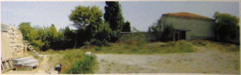
The miscellaneous Preserve buildings, storage barns, dachas, the Hologram Museum, the mosaic display, stoas, the Yacht Club buildings, and various storage containers distributed about the grounds are all ad hoc, temporary solutions to permanent needs.
GENERAL CONCLUSIONS
In almost every case, problems encountered at the Museum and throughout the Preserve are the result of shortages, whether of storage space, conservator working space, or student housing. The Preserve administrators and staff simply do not
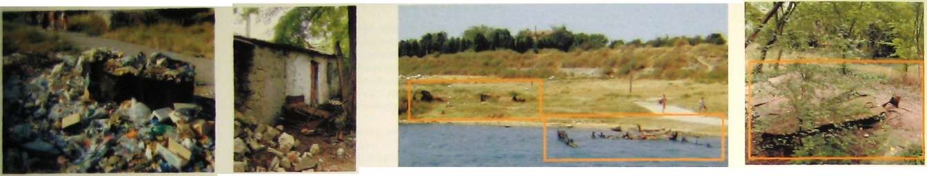
98 Improper disposal of garbage & waste material
99 Unsafe rusted material throughout the Preserve's grounds

100 Disruptive placement of utilities

103 Proliferation of sheds at the dock
104 Destructive unattended fires

101 Overgrown 102 Improper disposal of spoils and improper vehicular traffic landscape
105 Improper parking and construction

107 Graffiti
108 User's climbing ancient structures
106 Unknown activities
have enough materials or resources. They are not wasteful or careles s—they are simply shorthanded and undersupplied.
Storage space for archaeological material is rapidly being depleted and soon will be consumed. The current level of security, mechanical soundness, and amenity is not consistent with the Preserve's goal to be a regional center for the study and exhibit of ancient civilizations. Unfortunately, the current economic conditions of the country mean that the Preserve cannot face these problems alone. The Preserve shares the dilemma of inadequate resources with the entire population of Ukraine. (See pictures 98-108)
However, as a result of the current economic conditions, societal cohesion is high and, due to societal bias toward the support of exploration and preservation of cultural patrimony, the Ukrainian people, through the actions of their parliament, have prioritized the creation of parks and preserves. It is hoped the combined Ukrainian social consensus, along with abundant evidence of the ability to "do the most with the least," will make it possible for the Preserve (and the city of Sevastopol) to parlay momentary assistance into a self-sustaining process of improvement. The creation of a master plan simply defines a path in pursuit of improvements.
A comprehensive collaboration among national government, local government, local expertise, invited expertise, and the citizens of Sevastopol will be required. History has woven the landscape of Chersonesos into a robust and diversified natural and cultural treasure. A singular approach to preservation will not improve the situation of those ancient artifacts. The Preserve can be a thriving component of the contemporary city. The proposal must help the citizens of Sevastopol realize the great potential of the Preserve without losing their access to the sea or the Cathedral.
The management plan must also foresee the appropriate reutilization of adjacent military land as it is decommissioned to house departments of the Preserve. That relocation will remove pressure on the grounds. As part of that redevelopment, existing housing at the boundary of the annexed military land should be stabilized and augmented, not displaced. Those initiatives will foster a revitalizing co-existence with a community now experiencing a housing scarcity and other shortages. Finally, the management plan must gain codified integration in the regional plan of metropolitan Sevastopol and its subsidiary administrative areas. That statutory recognition of the Master Plan will avoid an endless repetition of governmental review for approval.
PROPOSED PROGRAMING
Additional Spatial & Functional Requirements
|
Exhibit space |
1,000 |
m 2 |
Phase I |
|
Storage space 'fondi' |
6,000 |
m2 |
Phase I |
|
Conservation Lab |
300 |
m2 |
Phase I |
|
Administrative/office space |
1,000 |
m2 |
Phase III |
|
Pottery Lab & Processing of Finds 300 |
m2 |
Phase I | |
|
Photo Lab & Studio |
30 |
m2 |
Phase I |
|
Drafting Studio |
20 |
m2 |
Phase I |
|
Student and |
4,000 |
m2 |
Phase I |
|
Visiting Scholar Housing | |||
|
Archaeological Field |
4,500 |
m2 |
Phase III |
|
School Campus | |||
|
Visitors Center |
500 |
m2 |
Phase m |
|
Hotel |
3,600 |
m2 |
Phase III |
|
Public Restrooms and |
800 |
m2 |
Phase I & II |
|
Changing Rooms | |||
|
Parking |
180 |
cars |
Phase III |
|
Commemorative Museum |
100 |
m2 |
Phase I |
|
Maritime Museum |
200 |
m2 |
Phasen |
|
Greek & Roman Museum |
300 |
m2 |
Phase I |
|
Byzantine Museum |
200 |
m2 |
Phase I |
|
Library |
100 |
m2 |
Phase I |
|
Archive |
100 |
m2 |
Phase I |
|
Grand Fondi |
1,200 |
m2 |
Phase III |
|
Maintenance Facility and |
1,200 |
m2 |
Phase III |
|
Machine Shop | |||
|
Arboretum and |
2,600 |
m2 |
Phase III |
Horticultural Conservation Phase I Dacha Plots
Soil & plant stocking facility to provide plant propagation and services, 0.4 Ha
Phase in Open Space
Re-creation of Ancient City fabric, 0.6 Ha
Public Park as part of storm water filtration system, soil building and nursery services, 0.8 Ha Dedicated maintenance yard, 0.24 Ha
II Layout & Circulation
Resolution of circulation conflicts between religious visitors, Preserve
patrons & swimmers Segregation of beach traffic from ruins
Most intense planting must occur inside monastery precinct to control
expenditure of recourses Low or no maintenance planting must occur in the peripheral regions of
the Preserve grounds Storage (fondi) space should always be associated with adjacent workspace Workspace should always make the greatest use of natural lighting as is feasible
Placement of special finds and other valuables in a high security, high supervision area
III Operational Requirements
Admission to Preserve exhibits by ticket purchase Raise levels of security and climate controls in museum facilities Support of exchange of exhibits with pier museums Support of religious activity at the cathedral Free access to the Cathedral Provision for trash receptacles and pick-up Organization/hierarchy of landscape maintenance: as to intensity v. location, manpower, watering requirements, appearance, i.e. high detail & high maintenance settings Prevention of vandalism & site security enhancements Management plan for excavation spoils Relocate family living in structures at the north end of the former military base
IV Infrastructure
Install all improvements and retrofits in a manner that gives protection to the cultural layer
Consideration of aesthetics: reduction of exposed infrastructure such as
power lines and poles Improvement of municipal water supply and distribution service connection
Achieve electrical self-sufficiency with back-up electrical power & supple
mental power supply Modernize Preserve sewer system to adequately handle present
and future demand Stabilization and improvement of all mechanical (plumbing, gas, etc) systems
Rehabilitation of existing rainwater collection system
Rehabilitation/repair of existing physical plant Site Lighting
Preservation
Treatment, management, & thematic context as per Chusid and Ryzhov Conservation of the existing excavations in the Ancient City Integration of the established archaeological excavation schedule with
the master plan The mitigation of Black Sea's erosion of Chersonesos Stabilization and conservation of modern/war artifacts built upon the Ancient City
Conservation of the fabric of the existing, surrounding urban neighborhood
• Design Description
• Implementation
MASTER PLAN PROPOSAL
DESIGN DESCRIPTION
The long-range plan seeks to address the following issues:
1. Facilities improvement;
• enlargement of exhibit space
■ enlargement of artifact storage capacity
• enlargement of space for scientific analysis
• preservation of the exposed Ancient City
• preservation of war monuments
• preservation of religious monuments
• preservation of the seashore
• rehabilitation of open spaces
2. Resolution of conflicts in the principal user groups' patterns of use
• neighboring residents
• Preserve visitors
• swimmers
• religious visitors
3. Integration of the Preserve facility in the urban fabric of the adjoining neighborhood.
Because the Preserve grounds occupy large portions of one of Sevastopol's best sea edges, the proposed modifications must consider this seaside district's circulation and orientation toward the sea. Although set apart from the city by its nature as a preserve of ancient Chersonesos, the Preserve grounds cannot be effectively dealt with unless their place in the public's perceptions as a seaside public space and holy ground are accommodated with pragmatism, respect, and sensitivity. The Preserve and the City must work together.
The complex urban fabric can only be constructively amended with the intense collaboration of many constituent groups. National government, local government. Preserve officials, the citizens of Sevastopol, and invited specialists must move in unison in order to form an appropriate plan. In particular, the full and earnest cooperation of the surrounding local population must be present if the proposed improvements are to take hold, flourish, and avoid vandalism or neglect. If the Master Plan causes collateral improvement to the situation of Preserve neighbors in measurable and personally tangible ways, the tremendous investment of national resources and requisite endurance of institutional resolve will not be perceived as wasted.
Entrance to Preserve
Drevnyaya Parking Plaza
Peribol Promenade
Tower of Zeno
West Ancient City Walls
Existing Excavation of the City
Mall with Entry Plaza & Ancient Mint
Byzantine Museum
• Second Floor - Byzantine Exhibits & Executive Offices
• Ground Floor - Archives, Library & Administrative Offices
• Bottom Floor - 'Fondi' Storage Greek & Roman Museum
• Second Floor - Greek and Roman Exhibits
• Bottom Floor - Greek and Roman Exhibits and Cafe
Visitors Center
• Second Floor - Conservation/Restoration Office Space
• Ground Floor - Visitor Center
• Bottom Floor - Conservation/Restoration Laboratory Space
Chapel
Chapel Plaza
Preserve Peristyle
Ancient Theater Precinct
Ancient Baths (Therma) & Reservoir Precinct
Italian Garden
Library Garden
Exhibit Garden
Commemorative Plaza
St. Volodymyr Cathedral and Cloister
Ancient Port and Associated Ancient Urban Fabric
Pottery and Conservation Laboratory
• Second Floor - Conservation/Restoration Office Space
• Ground Floor - Pottery, Conservation/Restoration and Photo Lab
• Bottom Floor- Conservation/Restoration Lab and Field Archaeology Training Space 'Fondi' Storage Quadrangle
Commemorative Hall
• Second Floor - Belvedere
• Ground Floor - Commemorative Exhibit
World War I Artillery Battery Outdoor Commemorative Exhibit, Archaeological Field School Housing, and Subterranean Archival 'Fondi' Storage Space Preserve Dock Vendor Plaza
Shoreline Promenade and Public Swimming Facilities Greenhouse
Staff & Rental Units and Preserve Plant Propagation Gardens Preserve Restrooms
North


National Preserve of Tauric Chersonesos
Master Plan
Phase I
Therefore, the current proposal seeks to engage the earnest support of the citizens of Sevastopol by recognizing that the proposed enhancement of the Preserve is also a thriving component of the contemporary city. In fact, the proposal develops itself around the mutually beneficial development, socially and economically, of the Preserve, within the framework of Sevastopol and Ukraine.
Phase I
Phase I focuses effort on those improvements that make the greatest beneficial impact with the least expenditure of resources. The renovation of the student housing adjacent to the WWI Artillery Battery can be accomplished quickly with minimum preparation and disturbance. The improved housing is essential to safe accommodation of the summer archaeological campaigns, freeing the seaside dachas for renovation and use by seasonal renters. The outdoor work space proposed between the new housing units and the Battery will remove the need to drive buses and delivery vehicles through the center of the Preserve grounds. Movement of materials between the fondi and scientific buildings would then be accomplished with small electrically powered vehicles and lifts.
Reorganization of the Preserve exhibit entry sequence as designed by Nikolai Andrushenko and Tatiana Bazhanova can be accomplished immediately. The Drevnyaya Street Parking Plaza and the Vendor Plaza can be organized quickly in cooperation with the existing businesses due to the minor amount of reconfiguration required. Each of those changes can take place with a minimum of time and money. With those simple improvements, entry to the Preserve will mirror the Ancient City's entry sequence, greatly magnifying its impact.
Phase I also makes use of the Preserve's existing excavation schedule to more directly focus the entry on the collection of exhibits. The Ancient Theater and Mint are high priorities on the excavation schedule. The spatial side effects of Theater and Mint excavation naturally channel visitors to the heart of the Preserve's exhibits and the Museum complex. By including those excavations in the development sequence of phase one, the Preserve Mall is made possible. The Mall directs Preserve circulation from the Ancient City entrance gate at the terminus of the City Wall entry directly to the Italian Court adjacent to the Greek, Roman, and Byzantine Museums. Visitors are given a continuous view of the Ancient Theater Excavation along the western edge of the Preserve Mall and pass the Ancient Mint as they arrive at the Italian Court.
The eastern edge of the Mall is defined by the boundaries of the Library Garden. The garden contains reading tables beneath its tree canopies and one of the two mosaic display shelters. The transparent shelter serves as a threshold to the garden displaying mosaics under glass pavement to display them in the proper orientation in direct sunlight. As library patrons cross toward the reading tables they cross over the mosaics. This garden and the Mall's other edge-defining buildings, courts, 48
Byzantine Museum
Mosaic Display with overhead Rainwater Collection/Fountain System rainwater collection structure
Walkway at south facade of Byzantine Museum
Library Garden and Mosaic Display

This awning is roofed with glass to allow the sunlight to strike the mosaic's surface so that visitors may view it as intended. The Mosaics are displayed slightly below ground surface and protected by glass pavement that allows an observer to have the sensation of walking across an ancient mosaic.
Arbor palisade
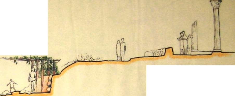
Preserve level
Black Sea
Large gravel beach
31- Restrooms/changing rooms underneath the end of the central
promenade
Plan of Arbor Palisade & Restrooms/Changing Rooms
Carved walkway
Preserve level

Restrooms/changing rooms

Black Sea
Cliff Face Restrooms/Changing Rooms
and excavations define the boundaries of the Inner Campus, which approximates the extent of the unexcavated ancient acropolis several meters beneath.
The Inner Campus and its compliment, the Outer Campus, are the principal organizational distinctions within the Preserve. That separation allows visitors of all sorts to enjoy the views from the approximate location of the ancient acropolis free of charge. In this fashion, the Preserve will have the same accessibility in the minds of Sevastopol as the civic monuments at its contemporary center adjoining the modern harbor. This temporal cross-connection carries greater impact when experiencing the commanding views the Ancient City affords toward the current city center. It is hoped these symbolic associations will further endear the Preserve to the citizens of Sevastopol.
An additional effect of encouraging Theater, Mint, Baths, and Reservoir excavation to proceed in earnest is the isolation of the Inner Campus, roughly the extent of the former monastery, from the remaining, or outer campus, areas. That separation creates the opportunity to naturally segregate pedestrian groups. Problems, such as having to charge admittance to religious visitors, are automatically avoided because all of the operational religious monuments will be contained within the Inner Campus zone. The indiscriminant foot traffic of swimmers is easily redirected by the proposed addition of gates to rejoin the existing segments of the former monastery walls. That rehabilitation creates a minimum of 150 meters of buffer between the Inner Campus and the seashore.
Swimmers, like all visitors, may have unhampered access to the entire inner campus portion of the Preserve without purchasing a ticket. However, swimsuit attire will be out of place considering shore access must now occur at the beach's Sand Bay entrance. That detour will be rewarded with the availability of restrooms, shade structures, and other amenities along the shore. And those who wish to follow their swim with a visit to the Preserve and Museum complex within it may purchase a ticket at one of two beach ticket booths, provided they avail themselves of one of the two dressing rooms first so as to don proper attire.
The local citizens, Museum visitors and religious visitors may use the ground level entry at the vendor plaza to enter the Inner Campus zone without a ticket. Only when a person descends into an excavation or enters the exhibit sections of a building would they be required to present a ticket purchased for that particular attraction at one of the perimeter access control stations. Those stations exist primarily to provide information and monitor egress points along the shores and to the excavations.
Those excavations include the entirety of the Outer Campus, which contains the areas of contiguous excavation of the Ancient. City and modem war monuments. The visitors travel across the landscape in clockwise arcs. The journey begins at the west gates of the Italian Gardens or the Chapel Plaza, featuring the sparsely

Enlargement of Phase I Inner Campus Area
excavated southern section of the Ancient City first. Way-finding signage encourages a detour to the top of the WWI Artillery Battery to experience the vast size of ' that war monument and to experience the commandingly comprehensive view of the entire Preserve territory. Once atop the rampart, visitors will clearly see the continuous excavations of the Ancient City they are about to visit. The excavations 20 expose the cultural layer best preserved. Greek, Roman, and Byzantine ruins emerge and recede, illustrating the timeless character of city structures and symbolically . organizing the Preserve complex.
The Phase I effort concentrated on the Inner Campus establishes pedestrian circulation changes as rapidly as possible to protect and stabilize the prior excavations of the Ancient City at the earliest possible date. The topographical arrangements that naturally result from proposed excavation are used to reorganize the open spaces of the Preserve in order to protect, conserve, and more prominently display the archaeology of the Preserve. In addition, the core of the exhibit, scientific, storage, and administrative spaces placed within the former monastery buildings of the inner campus receive the attention they deserve as soon as possible to arrest further deterioration and speed rejuvenation.
Within the broad initiatives are a multitude of beneficial small projects that accumulate over the estimated six-year span of Phase I. The current grazing of goats and the harvesting of grass to control vegetation on the largely unexcavated regions of the Preserve will continue. That maintenance program will be expanded to include local gardeners who would assist in maintaining plant propagation gardens in return for use of garden space and waiver of admittance fees.
The small projects include the creation of several outdoor work areas and an outdoor lecture court in the Preserve Peristyle near the fondi and scientific buildings. Those work areas are fenced courtyards that allow visitors to view the initial intake and restoration of artifacts retrieved by the various field campaigns. The work areas further the Preserve's educational outreach to its visitors and the boundaries of those work areas assist in organizing the pedestrian flow. The lecture court is centered upon the transplanted cruciform mosaic displayed adjacent to the new Visitors' Center auditorium. The court is a tour staging area and acts as overflow seating for the proposed Visitors' Center.
The Commemorative Plaza is part of that educational outreach. The plaza is defined by the edges of the smaller gardens and the buildings that surround it. Principally, that definition arises from the Cathedral and its apron of Byzantine archaeological remains to the east and the Preserve's main building to the west. The distance between those buildings establish the plaza's width. The plaza's size and placement make the architectural repose between the Cathedral and Preserve s main building clear, creating a space of civic scale directed toward Sevastopol as a whole. The Preserve Exhibit Garden and a line of statues commemorating individuals important to the development of the Preserve or the defense of Sevastopol
further define the plaza's western edge. The Exhibit Garden supplements the grand activities of the plaza with more contemplative strolls "through the collection of ancient monuments, or the opportunity to gaze at the Black Sea from one ofjta' shaded benthes.
The Commemorative Plaza and surrounding gardens can be used the Preserve's administration to broaden the Preserve's connection to Sevastopol. The plaza is intended as the venue for a variety of civic gatherings, concerts, and festivals. Push cart vendors licensed by the Preserv could serve those activities. The licenses purchased to use the plaza or to operate as a vendor create a new revenue sources. However, the primar purpose of this section of the campus is to further the Preserve's beneficial impact on the education of the public.
Improvements to utility infrastructure and buildings will also occur as an aggregation of many small projects. The overall goal will be the rerouting of all utility conduits into concealed above-ground containment in conjunction with structural replacement of all roof assemblies throughout the inner campus. In addition to removing threats to the cultural layers of the inner campus soil, the restructuring will speed and simplify the modernization of campus utilities. Once that upgrade is complete, environmental controls in each of the exhibit, scientific, and office spaces can be brought to the standard required of a regional teaching museum. Trash collection will be systematized through the use of small electric collection vehicles which deliver daily to a single collection station for removal by contract refuse services. The entire site will be made accessible to the mobility impaired through* a painstakingly methodical program of path improvements, building improvements, and the addition of an assortment of interior and exterior elevators and stair lift devices. The full six-year span of Phase I will be consumed in the execution of those projects.
The work above grade will be complimented with a subterranean agenda of renovation and rehabilitation. The basements levels of the Preserve main building, conservation building, and the west-most' fondi' require re-excavation and installation of damp proofing and drainage. The largest of these subterranean projects is the reopening of the WWI Artillery Battery lower levels. Those lower levels, once converted to storage space, have enough capacity to prevent the Preserve and its collaborators from ever facing artifact storage shortages again. These recaptures of basement space will allow the Preserve to reconfigure space allotments increasing exhibit space in the Greek and Roman Building and Library/Archive space in the main building.
Scientific space will be increased by another route, the southern storage barn will be razed and a new Conservation/Restoration and Pottery Laboratory will be built.

Enlargement of Dacha Renovation Prototype
A Seasonal Propagation, Cut Flower, Culinary Herbs and
Vegetable Garden B Private Dining Garden C Reading Garden
D Archaeological Remain displayed as a Garden Follie E Arbor
F Native Grasses with "Ha Ha" ledges and Pocket Wildlife Habit
G Trash Bins and Compost Bins
H Outdoor Garden Showers with Changing Room and Restroom I Fireplace and Shashlyk
Phase I Preserve's Areas Legend
The northwestern section is accessed from the existing city beach at Sandy Bay. It has controlled access into the Preserve at two points. Amenities for the swimmers have been provided along with restrooms. The Promenade is defined by a series of arbor palisades and linear boardwalks that incorporate erosion control structures along the endangered cliff faces. Long term improvement involves mitigation of wave energy and must be transparent to the landscape's form and ecosystem. The eventual solution awaits further study. The east portion is located by the existing Yacht Club. This area is only accessible by boat during Phase I. There is one controlled access point into the Preserve. During Phase II this shore segment will have a sand terrace at the waters edge bordered by a walkway that will later be developed into a vendors promenade with a Maritime Museum. This shore will be connected to Drevnyaya Street during the second phase of the Master Plan. The remaining shore south of the yacht club will be excavated to expose the ancient port.
Access to this area of the Preserve does not require the visitors to purchase a ticket It is meant to be an area that allows free enjoyment of the outdoor spaces. There are areas that can accommodate both large groups and small groups, while others are conducive to solitary contemplation. The inner campus will have exhibitions of plant material, traveling outdoor exhibits and accommodations for outdoor lectures. Festivals sponsored by the Preserve may take place in this area
This area has most of the continuously exposed archaeology. It not only includes some of the most impressive ancient structures but also has exhibits of modern warfare's history. Visitors will pay to enter this part of the Preserve. Guided tours for both large and small groups will be provided. However, visitors may also take self guided tours with the aid of itinerary signage that will be distributed throughout the area. The outer campus is approximately three fourths of the preserves grounds. Amenities such as water fountains, benches, lighting and trash bins will be placed throughout. During special events, areas like the theater can be isolated from the rest of the exhibits allowing a separate admission fee to be charged. That compartmentalization allows programs to operate independently from the Preserve's operational hours.
Preserve's Outdoor Work and Service Areas
The outdoor work areas are solely dedicated to the visiting students, scholars and Preserve's staff members and are located away from the circulation of the visitors. Work areas are fenced in a manner that provides security, while allowing visual connection to public areas to educate visitors about the scholars' work. These areas are amenities to the work environment of the scholars, students and staff members. The shaded outdoor spaces accommodate, pot washing, drying, sorting, outdoor feld preparation and classrooms. Some of the areas provide vehicular access for convenient unloading and handling of finds. Other areas are dedicated to parking preserve vehicles and housing trash bins.
Preserve's Plant Propagation Areas
The propagation areas are placed in the yards of the existing staff residences, dachas and the archaeology student housing Those plots contain gardens used to propagate seasonal plant material in conjunction with the greenhouse for the beautification and restoration of the Preserve. A relationship with local gardeners will be used to maintain the gardens. They care for the gardens and become docents to the Preserve in exchange for permission to grow certain food crops for their personal use. That practice is borrowed from Pereyaslav near Kiev. A prototype for the development of the dachas' yards is contained in the Phase I Master Plan at Dacha 1. The yard is organized into components to provide compost bin area for the production of rich soils, trash collection area, outdoor plumbing for irrigation of the gardens, outdoor showers and restrooms for the tenants, and outdoor dinning and reading gardens. Each yard may also have conserved archaeological remains incorporated in the design of the garden as in the Dacha 1 example.
The overlooks have optical aids and interpretiv e signage. They are located in areas that give the visitors vistas that enable better understanding of the ancient structures' geometries and the layout of the ancient city.
Visitors will pay to park in the Drevnyaya Parking Plaza

National Preserve of Tauric Chersonesos
Phase I Preserve's Pedestrian and Vehicular Circulation Controls Legend
Line of Separation between Shoreline Promenade and Preserve It is accomplished by use of an arbor palisade and topography. Swimmers enjoy the shade of the arbor while it separates them from the monuments. Preserve visitors will be allowed to access the shoreline through control gates.
Line of Separation between Inner Campus and Outer Campus It is accomplished by use of Preserve's buildings positions, fencing and topography. Visitors will be allowed to enter the Outer Campus area through the purchase of a ticket that will be shown at an entry gate point.
Preserve's Proposed Boundaries
It is accomplished by the use of existing buildings, fencing and topography
Preserve's Internal Fencing
Vehicular Gates
The gates are designed to control vehicular traffic into the Preserve. All vehicular gates include a 'man gate' for pedestrian access.
Free Access to Shoreline Promenade
St Volodymyr's Cathedral and Cloister Pedestrian Gates*
Pedestrian Gates into Work Areas*
Pedestrian Gates entering the Ancient Theater Precinct*
When theater events are scheduled, these gates serve as ticket vending locations
Pedestrian Gates entering into the Outer Campus Areas*
Pedestrian Gates exiting from Outer Campus Area*
Preserve's Pedestrian Flexible Gates*
Help the pedestrian circulation be redirected during special occasions
Pedestrian Main Entry Gate to Preserve's Paid Exhibits*
Pedestrian Gate to Inner Campus Area*
Preserve's Attendant Station
Provide information and ticket sales to guests. Control access
to paid areas. The locations are arranged to allow attendants
complete visual coverage of the Preserve areas.
Pedestrian Gate to Shoreline*
These gates are distributed along the Shoreline Promenade to help control access into the Preserve
'Pedestrian Gales -The gaits an used to control users into the various areas of the
Preserve. Certain pedestrian gates are designed to allow emergency vehicles access.
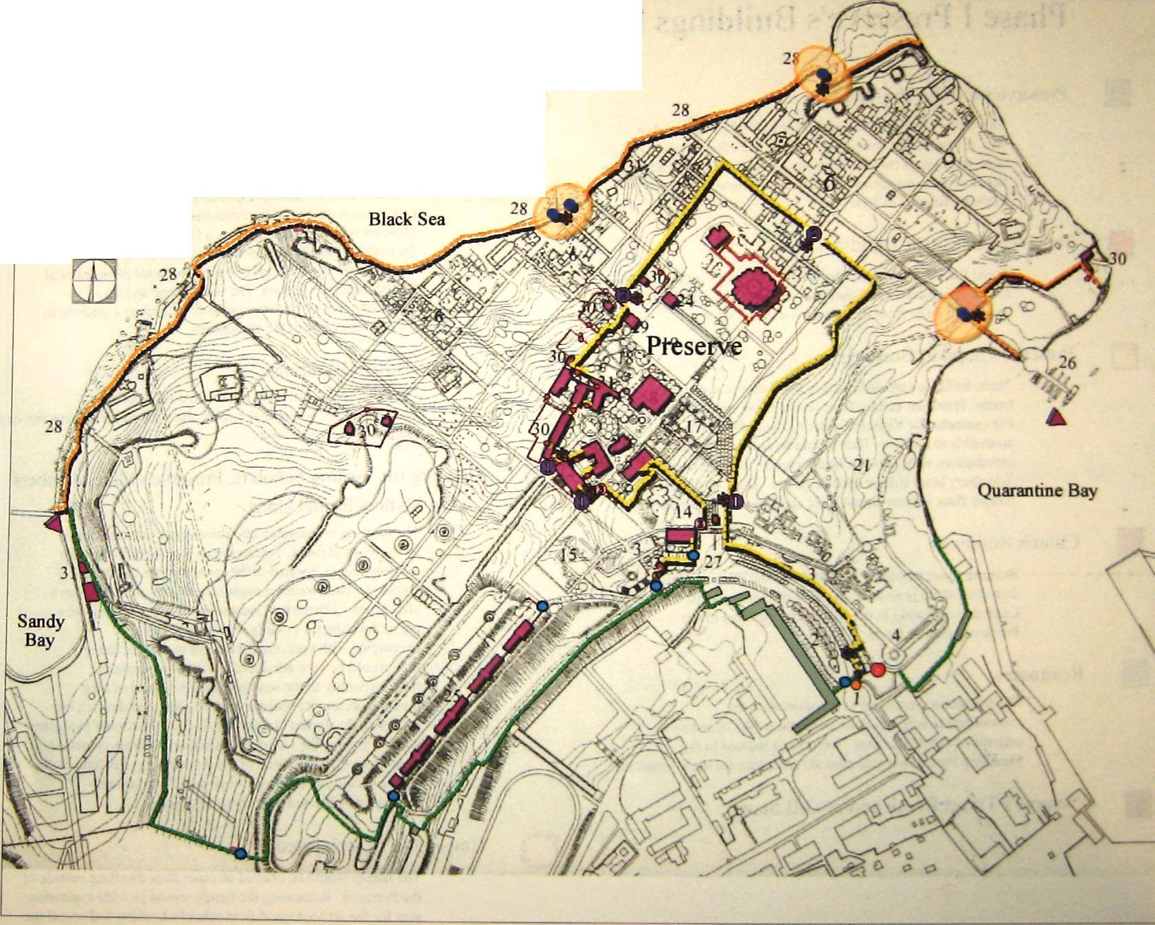
National Preserve of Tauric Chersonesos
Master Plan
Phase I
North
Phase I Preserve's Buildings Legend
The visitors will purchase tickets only for the exhibits that they are interested in touring. Visitors are otherwise free to walk throughout the inner campus without need of an admission ticket. This management practice is borrowed from Saint Sophia Cathedral in Kyiv.
Preserve's Scientific Buildings
Those buildings are dedicated to the staff and visiting scholars for the specified uses. Tourist are not allowed. The buildings arc placed away from the circulation of the visitors.
Those buildings are dedicated to the Preserve's operational needs. However, certain floor levels allow visitors to enter. For example, the Visitors Center's ground floor will be accessible to tourists. They would be able to view an introductory slide show or hear lectures. The top level of the monastery hotel will be used as an inn. The eastern half of it's bottom floor is commercial lease space accessible to the public.
Because those buildings are located in the inner campus free zone, there is no need to ticket the parishioners. Cathedral operating hours will be independent of the Preserve's exhibit hours.
The restrooms are placed to accommodate the visitors and to help maintain circulation and operational patterns of the master plan. Restrooms located in the Shoreline Promenade will provide amenities for the swimmers.
Preserve's Ticket Booth and/or Gift Shop
New Buildings Built on Existing Footprints
The Conservation and Pottery Laboratory will replace the existing storage sheds. To maintain the visual integrity of the Cathedral ensemble and the Preserve's grounds, the cloister will be redone to better compliment the architectural style and construction quality of the cathedral. The existing Hologram Museum will be rehabilitated as a Commemorative Museum, the existing mosaic display building will be replaced with a Greenhouse. It will be used to grow seasonal plant material for the Preserve's ground The Greenhouse and the Commemorative Museum ensemble will act as a gateway to the northern ruins of the ancient city.
These buildings will serve operational needs of the
Preserve. They are located outside the walls of the ancient city or
extremely disturbed areas.
Housing for Visiting Scholars, Preserve's Staff Members and/or Visitors Rental Units
The housing is separated into three zones that respond to the types of users. Selected staff members live in their existing homes, located in the inner campus of the Preserve. Their location improves security of the Preserve after hours. The dachas, located in the outer campus area, are rental units for visitors who wish to stay overnight Although, the dachas are in need of repair they would be very attractive to visitors because of their proximity to the seashore and the appeal of their quaint features. Revenue would be generated through the rentals of the dachas and the lop floor of the former monastery hotel. Housing for visiting field school students is located away from the circulation of the day visitors. Students will have a secure and generous work area They are also conveniently located near 'fondi 'storage
The family would be offered an equivalent dwelling outside of the Preserve. Relocating the family would provide expansion area for the archeological field school's housing and reveal the remainder of the WW1 Artillery Batten
National Preserve of Tauric Chersonesos
Master Plan
Phase I
North
Black Sea
Quarantine Bay
reserve
Military Compound
Phase II and Phase III
Phase II work concerns that portion of the existing Preserve campus which requires greater regulatory lead time such as the boat dock and the excavation of the ancient port on Quarantine Bay. Several maritime governmental agencies, both local and state, must grant their permission for work to begin at Quarantine Bay. The six-year duration of the Phase I work should allow enough time to prepare all of the necessary approvals.
Because of changes in sea level over the last 2,500, years the ancient cultural layers of the port section of Chersonesos will be found several meters below the water surface at Quarantine Bay. The proposal calls for the installation of de-watering bulkheads to create a cofferdam. The excavation of the Ancient Port may then proceed behind the cofferdam with the aid of sump pumps ("well points"). As in the other areas of the Preserve, the edges of the excavation provide a natural barrier to unauthorized entry. The cofferdam will be used as the foundation for a public boardwalk. That boardwalk connects the renovated dock with Drevnyaya Street immediately east of the Tower of Xeno and conceals the cofferdam. A public swimming area defined by floating markers will occur at the mid point of the boardwalk. That work will complete the shoreline promenade and return the waters' edge to the citizens of Sevastopol.
The existing bunkers near the dock will be rehabilitated for Preserve use. The largest structure will become a museum of coastal and maritime history. The small structures at the water's edge that are occasionally used as summer expedition housing will be modernized and converted to operate as grounds caretaker housing. (Past incidents of theft from the sea side make vigilance at the dock a necessity.) The shore margin between those rehabilitated buildings and the dock will be cleared of all incidental structures and covered with coastal sand. That sand terrace will serve as the collection point for Quarantine Bay activities and be the location for public restrooms and vendor services. As in other Preserve areas, the licenses issued to vendors provide additional revenue.
Phase III work concerns the military property that will be ceded to the Preserve, which will require great regulatory lead time to secure. The ten-year duration of the Phase I & II work should allow enough time to complete the transfer. After a thorough cultural survey to determine whether military base construction left any of the ancient cultural layers intact enough to preserve, the construction of an ensemble of entirely new facilities may begin. That effort will consume the final ten years of the Master Plan.
The Preserve now becomes the City. As the Preserve uses this land to reach its full potential as a regional archaeological exploration, curation, and teaching institution, it must inhabit the land in a fashion that strengthens the immediate urban fabric by addressing pressing civic needs in addition to its own, such as housing 60
and neighborhood preservation. It is hoped the Preserve's mere presence will allow it to claim credit for preventing a blight-inducing vacuum from forming after the removal of the garrison. However, that alone cannot improve the neighborhood.
The proposal is structured around the re-institution of the street grid and resulting blocks. Those blocks will be organized around a new public park. The development contains two grid orientations. The first aligned with Drevnyaya Street and the surrounding district of Sevastopol. The second is aligned with the grid of Chersonesos. The new park resides at the intersection of the two grids and contains a large pond that acts as a storm water quality filter for the new development, in addition to providing the focal amenity of the park. The existing sliver of Sevastopol's residential fabric at the south edge of the ceded land will be preserved, and the existing business along the eastern edge of the former garrison will not be displaced.
The apartment buildings on Drevnyaya Street will be preseved and the current residents will not be displaced. The associated parking structures will be rebuilt, with housing for visiting scholars and tourists above them. The margin between the parking structures and the former military motor pool garage will be widened to create a boulevard extending from the north-south segment of Drevnyaya Street near the Tower of Xeno to the west, aligned parallel to the existing apartment buildings and proposed parking structures. This captive street will be called Korsun Boulevard and be dominated by pedestrian traffic.
Sevastopol Administrative Area planners have proposed construction of a bridge across Quarantine Bay springing from the east termination of the main section of Drevnyaya Street that would more directly connect the district with the city center. Should that plan proceed, Korsun Boulevard will allow Preserve visitor and staff traffic to operate at a safe distance from the likely congestion and higher speeds on the resulting thoroughfare. Korsun Boulevard will mark the transition from the residential fabric to the office and educational buildings of the Preserve. Also, the boulevard will direct the pedestrian flow of the new development toward the entrance of the Preserve, framing a view of the Tower of Xeno.
The Preserve's Administration, Library/Archives, and teaching and visitors' services will move to new buildings in the Phase III development. That relocation will allow the original campus facilities to be completely dedicated to curation, conservation, and restoration. The new buildings will include the Visitor's Center, the Tauric Preserve Administration Building, Archaeological Field School and the Hotel/Conference Center. Those buildings will occupy the northern edge of Korsun Boulevard opposite the new housing for visiting scholars and tourists. The existing topography allows the new buildings to conceal a parking structure beneath. The parking structure extends down into the prior excavation of the military motor pool and allows the new construction to make the transition smoothly down into
Entrance to Preserve
Drevnyaya Parking Plaza
Peribol Promenade
Tower of Zeno
West Ancient City Walls
Existing Excavation of the City
Mall with Entry Plaza & Ancient Mint
Byzantine Museum
• Second Floor - Byzantine Exhibits & Executive Offices
• Ground Floor - Archives, Library & Administrative Offices
• Bottom Floor - Conservation/Restoration Lab Space Greek & Roman Museum
• Second Floor - Greek and Roman Exhibits
• Bottom Floor - Greek and Roman Exhibits and Cafe
Visitors Center
• Second Floor - Conservation/Restoration Office Space
• Ground Floor - Visitor Center
• Bottom Floor - Conservation/Restoration Laboratory Space
Chapel
Chapel Plaza
Preserve Peristyle
Ancient Theater Precinct
Ancient Baths (Therma) & Reservoir Precinct
Italian Garden
Library Garden
Exhibit Garden
Commemorative Plaza
St. Volodymyr Cathedral and Cloister
Ancient Port and Associated Ancient Urban Fabric
Pottery and Conservation Laboratory
• Second Floor - Conservation/Restoration Office Space
• Ground Floor - Pottery, Conservation/Restoration and Photo Lab
• Bottom Floor- Conservation/Restoration Lab and Field Archaeology Training Space
'Fondi' Storage Quadrangle Commemorative Hall
• Second Floor - Belvedere
• Ground Floor - Commemorative Exhibit
World War I Artillery Battery Outdoor Commemorative Exhibit, Archaeological Field School Housing, and Subterranean Archival 'Fondi' Storage Space Preserve Dock and Sand Terrace with Vendor Space and Swimming Facilities Vendor Plaza
Shoreline Park and Public Swimming Facilities Greenhouse
Staff & Rental Units and Preserve Plant Propagation Gardens Preserve Restrooms
Quarantine Bay Promenade and North Shore Erosion Protection Maritime and Coastal Museum
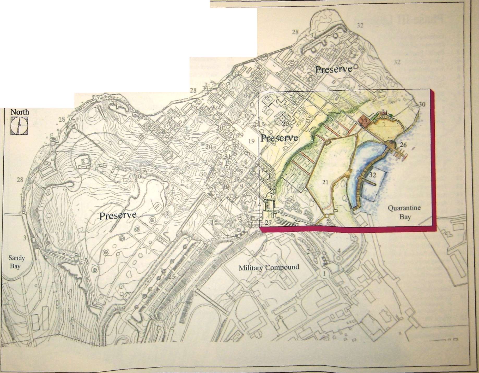
National Preserve of Tauric Chersonesos
Master Plan
Phase II Black Sea
Entrance to Preserve
Drevnyaya Paseo
Peribol Promenade
Tower of Zeno
West Ancient City Walls
Existing Excavation of the City
Mall with Entiy Plaza & Ancient Mint
Byzantine Museum
• Second Floor - Byzantine Exhibits
• Ground Floor - Public Library and Additional Exhibits
• Bottom Floor - Conservation/Restoration Lab Space
Greek & Roman Museum
• Second Floor - Greek and Roman Exhibits
• Bottom Floor - Greek and Roman Exhibits and Cafe
Visitors Center
• Second Floor - Conservation/Restoration Office Space
• Ground Floor - Conservation/Restoration Teaching Center
• Bottom Floor - Conservation/Restoration Laboratory Space
Chapel
Chapel Plaza
Preserve Peristyle
Ancient Theater Precinct
Ancient Baths (Therma) & Reservoir Precinct
Italian Garden
Library Garden
Exhibit Garden
Commemorative Plaza
St. Volodymyr Cathedral and Cloister
Ancient Port and Associated Ancient Urban Fabric
Pottery and Conservation Laboratory
• Second Floor - Conservation/Restoration Office Space
• Ground Floor - Pottery, Conservation/Restoration and Photo Lab
• Bottom Floor- Conservation/Restoration Lab Space and Field Archaeology Training Space
Scientific Offices/'Fondi' Storage Quadrangle Commemorative Hall
• Second Floor - Belvedere
• Ground Floor - Commemorative Exhibit
World War I Artillery Battery Outdoor Commemorative Exhibit, Archaeological Field School Student Housing, and Subterranean Archival 'Fondi' Storage Space
Preserve Dock and Sand Terrace with Vendors and Swimming Facilities Vendor Plaza
Shoreline Promenade and Public Swimming Facilities Greenhouse
Staff & Rental Units and Preserve Plant Propagation Gardens Preserve Restrooms
Quarantine Bay Promenade and North Shore Erosion Protection
Maritime and Coastal Museum Preserve/Field School Administration above Parking Structure
• Third Floor - Tauric Preserve Executive Offices
• Second Floor - Tauric Preserve Administration Offices
• Ground Floor - Field School Administration Offices and Conference Rooms
• Basement - Parking
Archaeological Field School above Parking Structure Tauric Preserve Visitors' Center and Conference Center above Parking Structure
• Third Floor - Library
• Second Floor - Archive
• Ground Floor - Visitor Center/Conference Center
• Basement - Parking
Hotel above Parking Structure
Stabilization and Enlargement of Existing Housing
Visiting Scholars' Apartments above Parking Structure
Civic Park/Arboretum
Korsun Boulevard
Retail Lease Space with Staff Housing above, Public Plaza and Restaurants Recreation of Ancient City Fabric Arboretum Conservatory
Conservation Offices, Preserves Design Administration Offices and NPTC Press Grand 'Fondi' Storage
Machine Shop and Building/Vehicular Services Maintenance Administration Maintenance Yard
National Preserve of Tauric
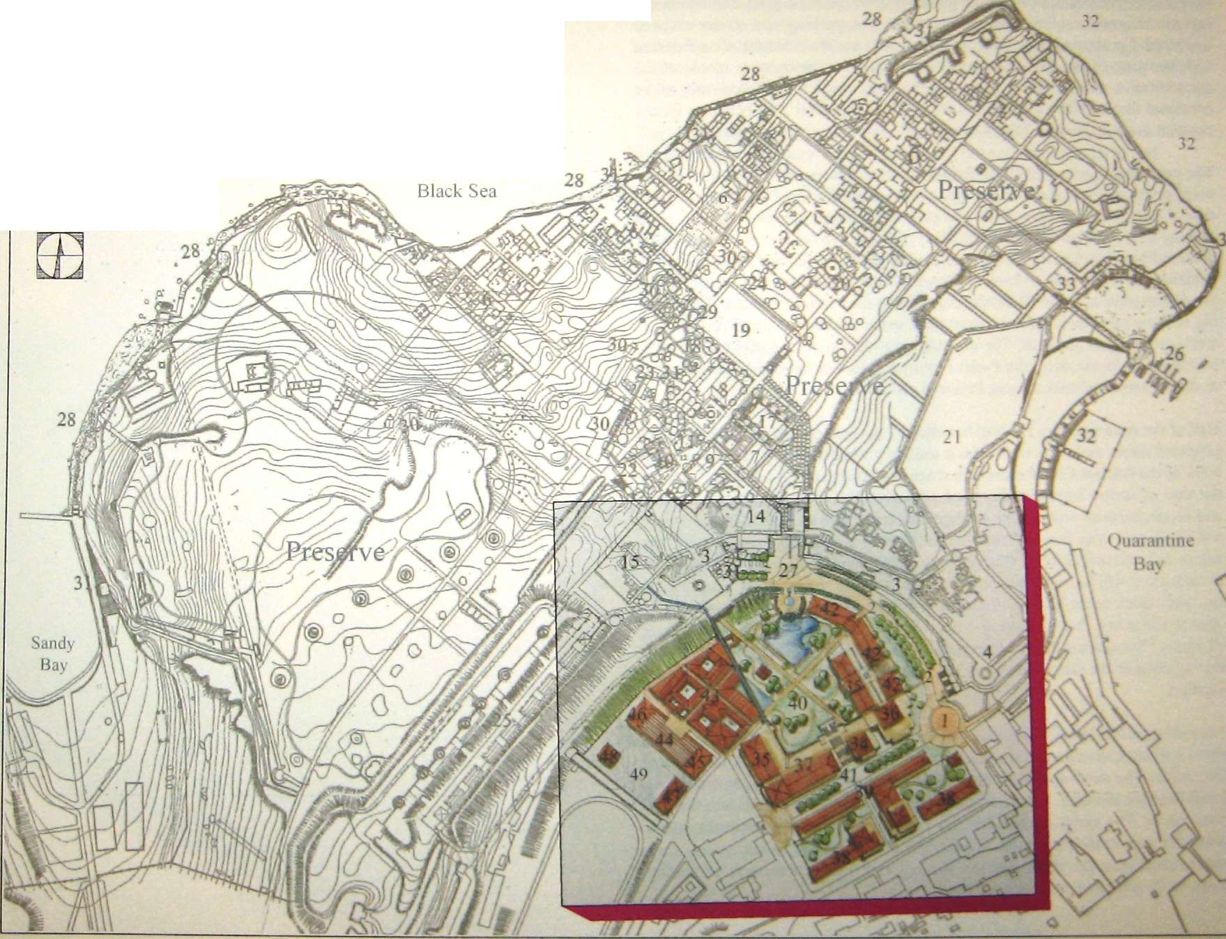
Chersonesos
Master Plan
Phase III
North
0
the bowl-shaped depression that the former military base occupied. The new build-: ings are arranged to allow meeting rooms, atriums, parking, and service cores to be shared. For example, the Hotel is placed between the Administration Building and one wing of the Archaeological Field School so the meeting rooms of the administrative office building and the auditorium of the Field School may all be combined for use when conferences are based at the Hotel. The buildings form a crescent around the rim of the sunken bowl of remaining military land.
The conserved businesses at the northern end of Drevnyaya Street are used to continue the crescent of new construction north to the Vendor Plaza. The combination of Korsun Boulevard and the new parking structure will allow removal of all parking from the Drevnyaya Parking Plaza of Phase I. What was used as a parking plaza in Phase I will now become a pedestrian plaza, called the Paseo Drevnyaya. Additional housing will be located above the conserved commercial uses along the eastern edge of Phase III development facing the Paseo Drevnyaya. That housing will increase the amount of apartment space available to local residents, as well as to students and staff. The increase in residential density might allow other businesses to locate along the Paseo Drevnyaya, further enlivening the entrances to the Preserve and encouraging Preserve visitation.
Half of the remaining bowl of land bounded by the new construction becomes the proposed public park. The remainder is used to accommodate recreation of a segment of the Ancient City and provide space for maintenance facilities suitable for the care of such a large and dispersed preserve. The new maintenance facilities and reconstructions will also be arranged around a grid of streets. Those streets will be aligned with those of the Ancient City to approximate properly the sun angles and microclimates of Chersonesos. The exhibit of Ancient City block reconstructions will be separated from the machine shop, maintenance vehicle parking, and maintenance yard by the Arboretum Building. The Arboretum will be open to the public, but its primary purpose is the replenishment and husbandry of all Tauric Chersonesos Preserve landscapes. The visitors to the public park will be able to examine the various plants of the City and its Chora in a single convenient location.
The public park's elevation matches the elevation of the ancient City Wall and will allow a direct connection to the west entrance and the main gate of the Ancient City within. The north end of the park connects to the Vendor Plaza by means of a grand fountain staircase. That fountain includes a waterfall that spills into the park pond below. The various water features are also a means of transporting storm water drainage to the park pond. An example of a Roman aqueduct carries storm water runoff from the WWI Artillery Battery and Ancient Reservoir excavation down to the park and eventually its pond.
The pond functions as a habitat for pollutant absorptive plants and water organisms that purify the storm water runoff held there before that water is slowly released into the local watershed. The pond will enhance the visual appeal of the park and improve the water quality of the Preserve's storm water runoff before it enters the Black Sea.
The Master Plan prescribes an equitable way for Chersonesos to become both a living museum and a city that illuminates the history of both modern and ancient. The Master Plan is designed to be a tool for seizing the present opportunity to make the National Preserve of Tauric Chersonesos a precedent-setting historical and archeological complex.
Phase II & III Preserve's Areas Legend
The east shore segment has a sand terrace at the waters edge connected by walkway to the Maritime Museum, and the Quarantine Bay Promenade. At the center of the Promenade is a swimming area delineated by buoys. This area is accessible by boat and a pedestrian path that connects to Drevnyaya Street near the Tower of Zeno. This path is fenced to keep swimmers away from the preserve grounds. There is one access point into the Preserve.
Inner Campus and its Expansion
Access to this area of the Preserve does not require the visitors to purchase a ticket. It is an area that allows free enjoyment of the outdoor spaces. Hie expansion contains a public park with a central pond which also functions as a storm water quality filter. The park has exhibits of modem local plant material.
Preserve's Outdoor Work and Service Areas
Phase III adds a formal maintenance facility which serves the entire preserve. It contains a machine shop, repair shop, material storage yard, maintenance vehicle parking and garage.
Preserve's Plant Propagation Areas
Development Reserve
The overlooks have optical aids and interpretive signage. They are located in areas that give the visitors vistas of the surrounding territory
Internal Courts of Residential Blocks
Outer Campus
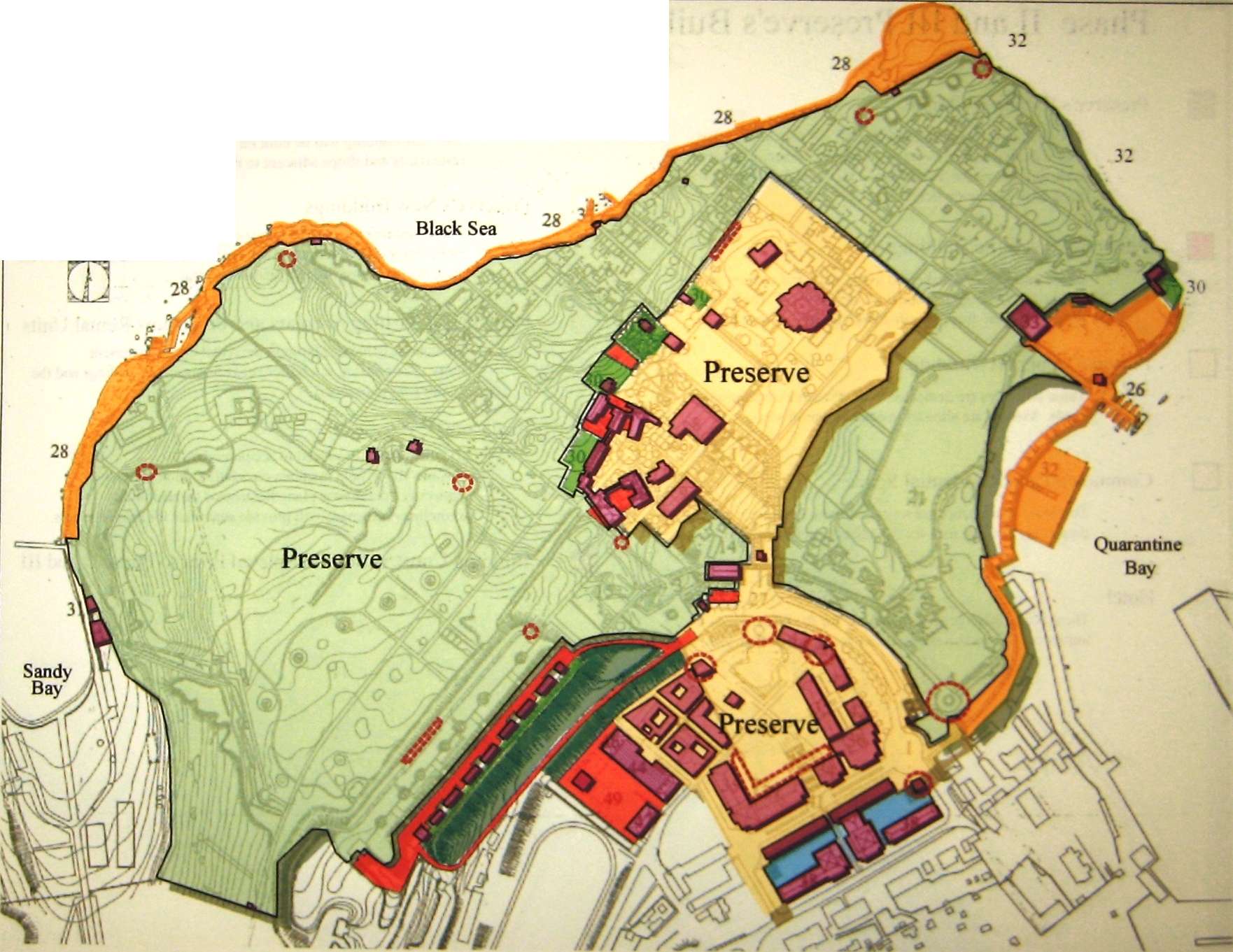
National Preserve of Tauric Chersonesos
Master Plan
Phase III
North
Phase II and III Preserve's Buildings Legend
The visitors will purchase tickets only for the exhibits that they are interested in touring. Visitors are otherwise free to walk throughout the expansion of the inner campus without need of an admission ticket.
Preserve's Scientific Buildings
Those buildings are dedicated to the staff and visiting scholars for the specified uses. Tourist are not allowed. The buildings are placed away from the circulation of the visitors.
Those buildings are dedicated to the Preserve's operational needs. Visitors are allowed to enter certain floors.
Commercial and Residential Space
This lease space generates revenue for the Preserve while preserving existing uses for the adjacent neighborhood.
Hotel
These hotel rooms generates revenue for the Preserve while improving tourist accommodations for the city of Sevastopol.
New Buildings Built on Existing Footprints
This new building will be built on the footprints of the existing restaurants and shops adjacent to the Drevnyaya Paseo
These buildings will serve operational needs of the Preserve and the archeological field school. They are located outside the walls of the ancient city or in extremely disturbed areas.
Housing for Visiting Scholars and/or Visitors Rental Units
Revenue is generated through the rental of the apartment units. The housing is a buffer between preserve buildings and the existing neighborhood.
The restrooms are placed to accommodate the visitors and to help maintain circulation and operational patterns of the master plan. Restrooms located in the shoreline promenade will provide amenities for the swimmers.
Building Construction Completed Prior to Phase II and III

National Preserve of Tauric Chersonesos
Master Plan
Phase III

Section Elevation A: Preserve Peristyle, Exhibit Garden, Commemorative Plaza
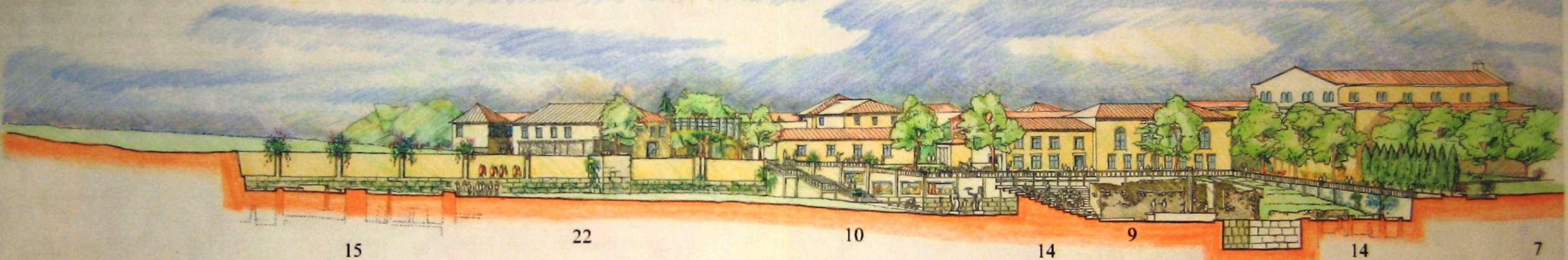
Section Elevation B : Ancient Reservoir & Therma , Ancient Theater, Proposed Entry Plaza

Section Elevation C : Archaeological Field School with parking structure, Civic Park/Arboretum, Vendor Plaza, Entry Plaza
Subterranean Archival Archaeological Field School
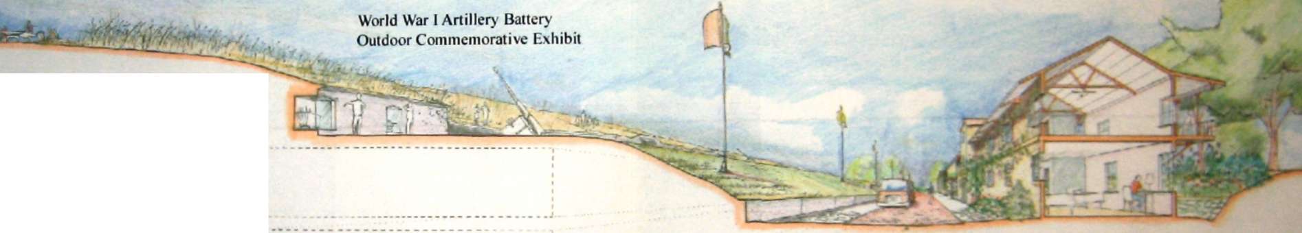
World War I Artillery Battery Itineraiy Signage and Optical Aids
'Fondi' Space Student Housing
Section Elevation D : WWI Commemorative Exhibit, Subterranean Archival 'Fondi\ Student Housing
IMPLEMENTATION
Once an urban design proposal is documented and accepted, execution of its constituent elements must be based on suitable implementation mechanisms. The design becomes a reality through careful expenditures of capital and other resources to create income (directly or indirectly) from which to build the proposals of the plan.
The Preserve will benefit from increased revenue from the vendor leases and rental income built into the plan. The enhancements to the Preserve's abilities to attract and accommodate visitors will increase revenue from admission ticket sales. Joint marketing efforts with the local tourist industry will eventually justify the construction of the hotel space and infrastructure used to attract and hold the monetary attentions tourists. The Preserve will use some of the land ceded from the military to 'capture' value it adds to the local economy in the form of increased tourist and employment activity. The Preserve can generate revenue from ground and building leases by preserving and enhancing the existing residential and commercial uses at the edges of the former military land. The Preserve can benefit from visitor spending on local lodging and food. The temporary and permanent residential needs of students, scholars and staff will generate rental revenue.
The effects of4 value capture' will be mild or barely noticeable at first; however, over the twenty years of master plan execution the impact of geometric growth will enhance the' value capture' contribution. The goal is to assist the Preserve in enhancing revenue to the point that it can preserve capital and begin to operate off income alone. The degree to which that goal is achieved is the direct correlate to the ability of the Preserve to implement its master plan.
However, the Preserve will not survive by "bread alone." Reciprocal arrangements with local residents and staff while reducing expenditures do greater work by creating a closer relationship with the community. The Preserve's livelihood and longevity are functions of its relevance to the community. The benefits provided to the public cannot be a purely academic anointing of National Cultural Patrimony. The Preserves relevance must be visceral and immediate. Strolls through the Preserve's exhibits, a momentary pause beneath the shade of its trees and a multitude of other small remembrances must become etched on the minds of Sevastopol. When visitors gaze upon the Preserve and its workings, they must see themselves. The faces of the caretakers, attendants and staff must be the faces of neighbors and not of strangers.
Public interaction must include a presence before all the local, state and federal governing bodies. New roads and bridges in the vicinity of the Preserve must be reviewed and beneficial influence negotiated when required. As local commercial organizations develop, the Preserve should seek relationships with those who seek 72
to cater to Sevastopol's many visitors and guests. Alliances with elementary, secondary and collegiate educational establishments will forever be the backbone of the Preserves outreach and service to the public. Continued collaboration with the Ukrainian agencies and invited specialists whose input help to form the master plan should continue as planning becomes implementation.
1. ENTRANCE TO PRESERVE
2. DREVNYAYA PASEO
3. ANCIENT CITY WALL PROMENADE
4. TOWER OF ZENO
5. WEST ANCIENT CITY WALLS
6. EXISTING EXCAVATION OF THE CITY
7. MALL WITH ENTRY PLAZA AND ANCIENT MINT
8. BYZANTINE MUSEUM, MUSEUM ADMINISTRATION & MUSEUM LIBRARY
9. GREEK & ROMAN MUSEUM
10. VISITORS' CENTER
11. CHAPEL
12. CHAPEL PLAZA
13. PRESERVE PERISTYLE
14. ANCIENT THEATER PRECINCT
15. ANCIENT BATHS (THERMA) & RESERVOIR PRECINCT
16. ITALIAN GARDEN
17. LIBRARY GARDEN
18. EXHIBIT GARDEN
19. COMMENORATIVE PLAZA
20. ST. VOLODYMYR'S CATHEDRAL & REBUILT CLOISTER
21. ANCIENT PORT & ASSOCIATED ANCIENT URBAN FABRIC
22. POTTERY & CONSERVATION LABORATORY
23. SCIENTIFIC OFFICES/ 'FONDI ' STORAGE QUADRANGLE
24. COMMEMORATIVE HALL
25. WORLD WAR I ARTILLERY BATTERY OUTDOOR COMMENRATTVE EXHIBIT, ARCHAEOLOGICAL FIELD SCHOOL STUDENT HOUSING. A SUBTERRANEAN ARCHIVAL 'FONDI' STORAGE SPACE
26. PRESERVE DOCK AND SAND TERRACE WITH VENDORS AND SWIMMING FACILITIES
27. VENDOR PLAZA
28. SHORELINE PROMENADE AND PUBLIC SWIMMING FACILITIES
29. GREENHOUSE
30. STAFF & RENTAL UNITS AND PRESERVE PLANT PROPAGATION GARDENS
31. PRESERVE RESTROOMS
32. QUARANTINE BAY PROMENADE & NORTH SHORE EROSION PROTECTION
33. MARITIME AND COASTAL MUSEUM
34. PRESERVE/FIELD SCHOOL ADMINISTRATION ABOVE PARKING STRUCTURE
35. ARCHAEOLOGICAL FIELD SCHOOL ABOVE PARKING STRUCTURE
36. TAURIC PRESERVE VISTORS' CENTER & CONFERENCE CENTER ABOVE PARKING STUCTURE
37. HOTEL ABOVE PARKING STRUCTURE
38. STABILIZATION & ENLARGEMENT OF EXISTING HOUSING
39. VISITING SCHOLARS' FLATS ABOVE PARKING STRUCTURE
40. CIVIC PARK/ARBORETUM
41. KORSUN BOULEVARD
42. RETAIL LEASE SPACE WITH STAFF HOUSING ABOVE. PUBLIC PLAZA & RESTAURANTS
43. RECREATION OF ANCIENT CITY FABRIC
44. ARBORETUM CONSERVATORY
45. CONSERVATION OFFICES & PRESERVE'S DESIGN ADMINISTRATION OFFICES
46. GRAND 'FONDI' STORAGE
47. MACHINE SHOP & BUILDING/VEHICAL SERVICES
48. MAINTENANCE ADMINISTRATION
49. MAINTENANCE YARD
Appendix
• Endnotes
• Bibliography
• Excerpts from Prior Studies
APPENDIX
ENDNOTES
1. Shearer & Jarvis 2000, 3.
2. Marchenko & Pevny 1999, 25-27.
3. Shearer & Jarvis 2000, 5.
4. Chusid 1998, 18.
5. Marchenko & Pevny 1999, 8.
6. Chusid 1998, 3.
7. Crevello 1998, 58-65.
8. Ibid, 124-139.
9. Chusid 1998, 2.
10. Rowe & Koetter 1978, 86,92.
11. Harris 1989, 25.
12. Ascherson 1995,43.
13. Carter, Crawford, Lehman, Nikolaenko & Trelogan 2000, 716.
14. Marchenko & Pevny 1999, 11,12.
BIBLIOGRAPHY
Chersonesos of Tauride. 1989. Kyiv
Crimea: Architecture & Monuments. 1991. Kyiv
Creation of an Archaeological Park on the Territory of the Tauric Chersonesos Preserve. 1997. Sevastopol: The Tauric National Preserve.
Priority-setting in Conservation: A new Approach for Crimea. 1999. Washington D.C.: Biodiversity Support Program, World Wildlife Fund.
Andrushenko, N.P. 1994. General Plan of the Development of the Preserve " Chersonesos Site of the Ancient City" (Conceptualization). Sevastopol: The Tauric National Preserve.
Ascherson, Neal. 1995. Black Sea. New York: Hill and Wang.
Carter, J.C., M.M. Crawford, P. Lehman, G. Nikolaenko, and J. Trelogan. October 2000. "The Chora of Chersonesos in Crimea, Ukraine." American Journal of Archaeology, Vol. 104, No. 4, p.p. 707-741.
Chisud, Jeffery M. 1998. Unpublished report. Preparing a Treatment and Management Plan for the Archaeological Park in the National Preserve of Tauric Chersonesos. Austin, Texas: The University of Texas School of Architecture and Planning.
Cordova, C. 1999. Unpublished report. Paleoecological Research in Southwestern Crimea. Stillwater, Oklahoma: Oklahoma State University.
Crevello, Gina Lee. 1998. Master's Thesis. Chersonesos: A Cultural Resource Management Plan for the Development of an Archaeological Park. New York: Columbia University Graduate School of Architecture, Planning, and Preservation.
Demin, N.M., and N.P. Andrushenko. 1991. Preservation Zones for Cultural and Historical Monuments and Definition of the Borders of the Areas of the Chersonesos Preserve on Heraclecm Peninsula in Sevastopol. Kyiv: Scientific Research Institute of the Theory of Architecture and City Planning.
Harris, Edward C.C. 1989. Principles of Archaeological Stratigraphy. San Diego: Academic Press Inc.
Jacobs, J. 1961. The Death and Life of Great American Cities. New York: Random House.
Marchenko, L. and O. Pevny. 1999. Preserving the Global Cultural Heritage in Post Cold War Ukraine. Austin: The Institute of Classical Archaeology.
Medvedeva, V.V. and A N. Shereshersky. 1996. City of Chersonesos: A Look Out of the Past. Sevastopol: ETNA.
Minns, Elliot H. 1913. Scythians and Greeks. Cambridge: University Press.
Rowe, C. and F. Koetter 1978. Collage City. Cambridge & London: MIT Press.
Shearer, B and D. Jarvis. Draft of October 17, 2000. Chersonesos Tauric National Preserve U.S. National Park Service Mission, October 4-12, 2000. Washington D.C.: The National Parks Service.
Zabolotny, V. 1993. The Development of Chersonesos Historic Archaeological Preserve in Sevastopol. Sevastopol: The Tauric National Preserve.
FROM
Scythians and Greeks By
Elliot H Minns 1913
Cambridge: University Press